
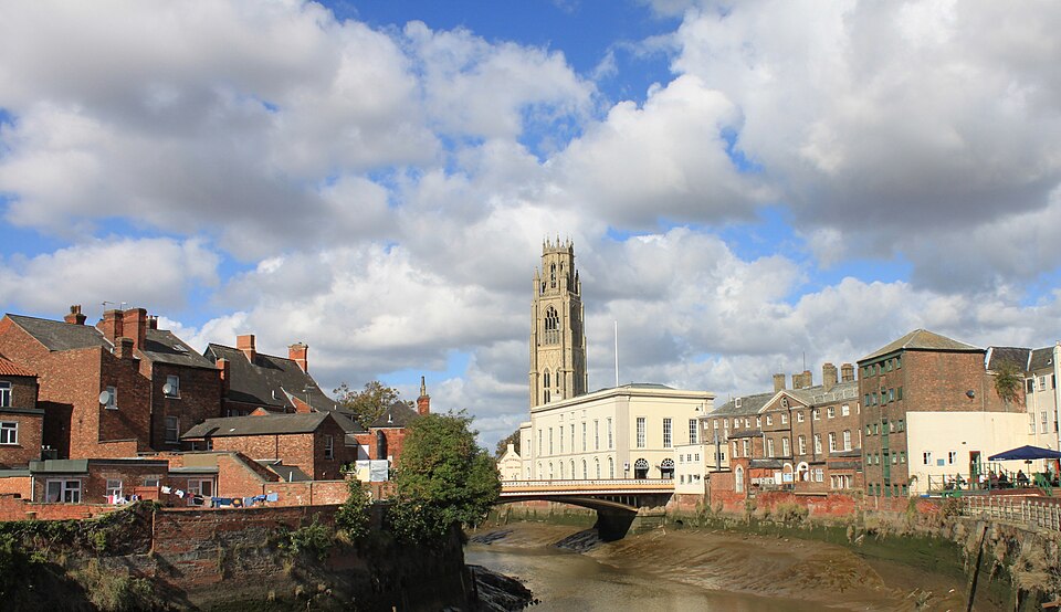

The second stage of the Tour of Britain begins and ends in two Lincolnshire towns whose histories were transformed by journeys away from them. From Boston, religious dissenters crossed the North Sea and eventually the Atlantic, carrying with them a name that would become attached to one of the great cities of North America. At Skegness, the movement came in the opposite direction: the arrival of the railway brought hundreds of thousands of people towards the sea, helping turn an obscure coastal village into one of the defining resorts of the British holiday.
Between them lies 180.2 kilometres of remarkably varied Lincolnshire. The stage begins among the drained lowlands around the River Witham before passing one of the most important concentrations of aviation history in Britain at Coningsby and Woodhall Spa. It then reaches Horncastle, turns through the Wolds crossed during Stage 1, and emerges at Louth beneath the highest medieval parish church spire in England. From there the peloton finally encounters the North Sea around Mablethorpe and Sutton-on-Sea before a last interruption at Miles Cross Hill and the fast approach to Skegness.
With only 873 metres of climbing, this should be a day for the sprinters. The landscape around them tells a rather more complicated story. Medieval merchants made Boston one of England’s great international ports, religious rebels challenged both the Church of England and Henry VIII, wartime aircrews departed Lincolnshire on missions from which many would never return, and engineers, railway companies and entrepreneurs later reinvented the coast as a place where industrial Britain could come on holiday.
Stage 1 showed us Lincolnshire through its land. Stage 2 increasingly shows us the county through the people who left it, defended it, rebelled within it and travelled across it.
START · Boston and the Medieval Port That Looked Towards Europe
The riders assemble in Boston Market Place, close to the River Witham and beneath a church tower so enormous that it seems strangely disproportionate to the modest town around it. That imbalance makes more sense when Boston is viewed not as the quiet Lincolnshire market town of today, but as one of the wealthiest trading ports of medieval England.
Between the 12th and 15th centuries, Boston was a major gateway between England and continental Europe. The River Witham connected the agricultural wealth of Lincolnshire with the North Sea, while merchants from across northern Europe came here to buy English wool and cloth and sell imported goods. Boston’s annual fair developed into one of the important commercial gatherings of medieval Europe, attracting traders whose networks extended through the North Sea and Baltic worlds.
Wool was at the heart of this prosperity. Medieval English wool was highly valued by continental textile producers, particularly in Flanders, and the vast sheep flocks supported by the eastern counties generated an export trade capable of enriching merchants, landowners and religious institutions. During the 13th century Boston ranked among England’s most important ports, at times second only to London in the value of its overseas commerce.
The surviving street plan still reflects that world. Medieval lanes run from the broad market place towards the river and church, while the Guildhall recalls the religious and mercantile associations that organised urban life. Boston was not peripheral England in this period. Ships connected it directly to an international economy stretching across northern Europe.
Its decline as a major port came gradually as waterways changed, larger ships demanded different facilities and patterns of trade moved elsewhere. Yet the extraordinary scale of medieval Boston remains visible in the building towering above the start of today’s race.
START · Boston Stump, the Giant Church of a Merchant Town
St Botolph’s Church is usually known simply as the Boston Stump, a nickname that makes one of England’s largest parish churches sound almost modest.
Construction of the present building began in 1309, during the period when Boston’s international commerce was generating considerable wealth. The church grew accordingly. Its great tower, begun in the 15th century and completed in the early 16th, rises more than eighty metres above the surrounding fenland.
Its effect is amplified by geography. There are no mountains around Boston and relatively few substantial hills. Across the flat Lincolnshire landscape, the tower becomes visible from extraordinary distances, functioning historically as both a spiritual landmark and a practical reference point for travellers and sailors approaching the town.
The dedication to St Botolph reaches further back. Botolph was an Anglo-Saxon saint traditionally associated with travellers and boundaries, and his cult became particularly strong in eastern England. The town’s own name is generally understood as deriving from “Botolph’s town”, gradually contracted into Boston.
That gives the starting point of today’s race an unusual linguistic afterlife, because this small English town eventually lent that same name to somewhere far larger.
The road from Boston, Lincolnshire to Boston, Massachusetts, however, begins not with geography but with religious conflict.
START · The Prisoners Who Helped Create the Story of the Pilgrims
In the early 17th century, a group of English Protestants had reached a dangerous conclusion: reforming the Church of England was not enough. They wanted to separate from it entirely.
Under James I, refusing to conform to the established Church could bring fines, imprisonment and persecution. Communities of these Separatists developed particularly strongly around Lincolnshire and neighbouring Nottinghamshire. Unable to worship as they wished, some decided to leave England for the more tolerant Dutch Republic.
Their first attempted escape in 1607 went badly, a group arranged to meet a ship near Boston that would carry them across the North Sea. Instead, they were betrayed. Local authorities arrested them, confiscated their possessions and imprisoned members of the group in Boston Guildhall before proceedings were taken against them.
They eventually escaped England and settled in Leiden in the Netherlands. Years later, some members of this wider Separatist community made another, much more famous journey. In 1620, they crossed the Atlantic aboard the Mayflower, becoming the group remembered as the Pilgrims of Plymouth Colony.
Boston’s relationship with New England deepened during the following decade. A much larger Puritan migration crossed the Atlantic in the 1630s, including people from Lincolnshire and the influential clergyman John Cotton, who had served for years at St Botolph’s. The settlement founded in Massachusetts was named Boston, preserving the name of the English town on the other side of the ocean.
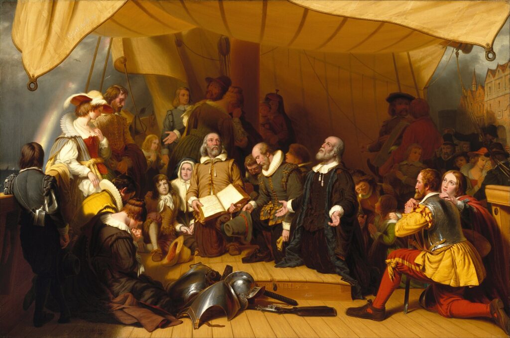
The American Boston would eventually become incomparably larger and more internationally famous than its namesake. Yet every time its name is spoken, there is a faint geographical echo of this Lincolnshire market town beside the River Witham.
The Tour of Britain begins only a short distance from the Guildhall cells where part of that transatlantic story began.
-155 km · Coningsby and the Aircraft That Still Fly for the Dead
After leaving Boston, the race turns north through the flat country of the Witham basin towards Coningsby, where the landscape acquires a different sound. Aircraft have been part of everyday life here for generations.
RAF Coningsby opened during the Second World War and remains an operational Royal Air Force station. Today it is associated with modern Typhoon fighters, but within the base is something entirely different: a collection of historic aircraft that are not preserved silently in a conventional museum.
The Battle of Britain Memorial Flight was created in 1957 to preserve operational examples of aircraft associated with the RAF’s wartime history. It moved to Coningsby in 1976, meaning that 2026 marks fifty years of the Flight’s presence here.
Its collection includes Spitfires and Hurricanes, the fighters inseparable from the Battle of Britain; an Avro Lancaster, the heavy bomber that became one of the defining aircraft of RAF Bomber Command; a C-47 Dakota, associated with transport and airborne operations; and Chipmunks used for training.
The important distinction is that these are not merely historic machines maintained for static display. Engineers preserve them in airworthy condition and RAF crews continue to fly them at commemorations, state occasions and air displays. Their engines, structures and systems therefore require a level of continuous technical care unusual for objects approaching or exceeding eighty years of age.
When one of the Flight’s Spitfires or the Lancaster passes overhead, the experience is consequently different from seeing an aircraft in a museum. The machine is operating in the same element for which it was built, producing the sound and movement experienced by the generation that originally knew it.
That experience is particularly powerful in Lincolnshire because the county once contained an extraordinary concentration of wartime airfields. During the Second World War, bombers departed these fields night after night for occupied Europe. Thousands of young aircrew lived temporarily in villages and bases across the county, and many never returned.
The peloton passes through a landscape where memory is sometimes still airborne.
-145 km · Woodhall Spa and the Dambusters
A few kilometres beyond Coningsby lies Woodhall Spa, an elegant inland resort whose villas and tree-lined roads seem an unlikely setting for one of the most famous bombing raids of the Second World War.
The connection centres on 617 Squadron, forever associated with the Dambusters Raid.
The squadron was formed in 1943 for a highly specialised operation against dams in Germany’s industrial Ruhr region. Conventional bombs were poorly suited to the task, so engineer Barnes Wallis developed a weapon designed to skip across the surface of water, avoiding protective torpedo nets before striking the dam and sinking beside its wall.
On the night of 16–17 May 1943, nineteen Lancaster bombers departed RAF Scampton under Wing Commander Guy Gibson. The operation breached the Möhne and Eder dams, causing catastrophic flooding and extensive destruction downstream. Eight of the nineteen aircraft failed to return, and fifty-three aircrew were killed.
The raid became one of the most famous operations in RAF history, partly because of the extraordinary technical problem involved and partly because of the enormous risks accepted by the crews. Its subsequent mythology sometimes obscured the human consequences on the ground, where the flooding killed civilians, forced labourers and prisoners as well as disrupting German industry.
After the raid, 617 Squadron evolved into a specialist precision-bombing unit and later operated from RAF Woodhall Spa. Its officers used the nearby Petwood Hotel as their mess, and the building retains a room associated with the squadron.
This makes Woodhall Spa an important complement to Coningsby. At the first, historic aircraft are preserved in flying condition as objects of remembrance. Here, the story becomes more intimate: young men lived, ate, planned operations and waited to discover who would return from missions over Europe.
The quiet Lincolnshire countryside around the riders once contained an industrial system built for aerial war.
-133 km · Horncastle, From Roman Walls to Britain’s Great Horse Fair
The race next reaches Horncastle, where the River Bain passes through a market town on the western edge of the Lincolnshire Wolds.
The Romans fortified a settlement here, and fragments of their walls remain embedded within the later town. The absence of a major Roman road through Horncastle has encouraged the idea that the Bain itself may have been important to the site’s function, providing a route through a landscape where waterways could be as valuable as roads.
Medieval Horncastle developed around a different form of movement: people bringing goods and animals to market. A market charter was granted in the 13th century, and over subsequent centuries the town became particularly famous for horses.
The Horncastle Horse Fair developed into an enormous annual event. At its height it was regarded as one of the largest horse fairs in Britain, attracting dealers, farmers, cavalry buyers and animals from across the country and beyond. For days the town could be transformed by thousands of horses and the people who came to buy or sell them.
Before mechanisation, horses were fundamental to almost every part of British life. They pulled ploughs and carts, transported passengers, moved artillery, carried cavalry and provided the motive power behind much of agriculture and urban transport. A great horse fair was therefore not a picturesque rural gathering but part of essential economic infrastructure.
Mechanisation eventually destroyed that world. Tractors replaced farm horses, motor vehicles replaced carts and military demand changed. Horncastle’s great fair disappeared in the 20th century, with the final event held in 1948.
The Tour of Britain now brings another kind of machine through the old market town, powered not by horses but by human legs.
-105 km · Binbrook and the Wolds Seen for a Second Time
At Binbrook, Stage 2 intersects with the route travelled by the peloton only twenty-four hours earlier.
The landscape is familiar, but the direction and context are different. The riders again enter the Lincolnshire Wolds, the chalk uplands formed from sediments deposited beneath a Cretaceous sea and later sculpted by erosion and glacial meltwater.
Yesterday these hills formed the geographical heart of the stage. Today they are an interruption between two very different Lincolnshires: the aviation country around Coningsby and Woodhall Spa to the west and the maritime landscape waiting beyond Louth to the east.
There is also another aviation layer here. RAF Binbrook became an important wartime bomber station and later one of Britain’s best-known Cold War fighter bases, particularly associated with the English Electric Lightning, the extraordinary interceptor designed to climb rapidly towards Soviet bombers approaching British airspace.
The base closed in 1988, but its surviving structures and the altered landscape around the former airfield remain another reminder of how thoroughly military aviation became embedded in Lincolnshire during the 20th century.
Fields that appear agricultural from the road can conceal the geometry of old runways.
-83 km · Louth and the Church Spire Built from Medieval Wealth
The race emerges from the Wolds at Louth, where one structure dominates the town from almost every direction.
The spire of St James’ Church rises nearly ninety metres above the streets, making it the tallest medieval parish church spire in Britain. Construction of the present church began during the 15th century, while the extraordinary spire was completed in the early 16th.
As at Boston, its scale is inseparable from the wealth of the surrounding countryside. Medieval Louth prospered through agricultural trade, particularly wool and grain, and money generated by that economy could be converted into architecture. A church tower was therefore not simply a religious structure. It was also a statement about the prosperity, confidence and collective ambition of the community that built it.
The technical achievement was considerable. Hundreds of tonnes of stone had to be lifted high above the town without modern cranes. Remarkably, part of the medieval machinery used to accomplish that survives inside the tower: an enormous treadwheel, operated by men walking within it to raise building materials through the structure.
From the road, the spire appears elegant and almost impossibly slender. Inside it survives evidence of the physical labour required to place every stone.
But St James’ significance extends beyond architecture. In 1536, its bells helped call Lincolnshire into rebellion.
-83 km · Louth and the Rebellion Against Henry VIII
By the 1530s, Henry VIII had broken England’s relationship with papal authority and begun transforming the religious and political structure of the kingdom. Royal commissioners were inspecting churches and monasteries, religious houses were being dissolved, and traditional communities increasingly feared that objects, wealth and customs associated with the old Church would disappear.
In Louth, those tensions exploded, on 1 October 1536 parishioners gathered around St James’ Church amid rumours that royal officials intended to seize church property. The bells were rung, summoning people from the surrounding area, and what began as a local confrontation rapidly became the Lincolnshire Rising.
Thousands joined as the rebellion spread through the county. Their grievances combined religious conservatism with anger over taxation, government policy and the influence of royal advisers. The rebels eventually marched towards Lincoln, presenting demands to the Crown.
Henry VIII’s response was uncompromising, he rejected their grievances and demanded submission. Without the organisation or military strength necessary for a prolonged confrontation, the Lincolnshire Rising collapsed. Its leaders were arrested, and several were executed.
The unrest did not disappear. Within weeks, a much larger rebellion known as the Pilgrimage of Grace erupted across northern England, again driven partly by opposition to Henry’s religious policies.
Louth therefore occupies a significant place in the history of the English Reformation. The same church whose spire was built from the prosperity of late medieval Catholic society became the place from which townspeople attempted to defend that world as the Tudor state dismantled it.
The peloton passes beneath the spire in seconds. In 1536, the ringing of its bells helped mobilise a county.
-55 km · The Lincolnshire Coast, Where the Land Never Quite Wins Against the Sea
Beyond Louth, the race leaves the chalk uplands and approaches an entirely different environment. The horizon widens, the ground flattens and eventually the North Sea begins to define the landscape.
The Lincolnshire coast is not a fixed boundary between land and water. It is a constantly negotiated zone of dunes, saltmarsh, mudflats, beaches and drainage systems in which tides and storms repeatedly reshape the edge of England.
North of the race route, the dune systems around Saltfleetby and Theddlethorpe form one of the important coastal nature reserves of eastern England. Here sand dunes, freshwater marshes and saltmarsh support specialised plants, migrating birds and rare animals including the natterjack toad, whose distinctive call can carry surprisingly far across suitable pools during the breeding season.
Further south, around Chapel Point, another landscape occasionally emerges from beneath the modern coast. At exceptionally low tides, remains of a submerged prehistoric forest can become visible, preserving tree stumps and organic material from a period when the shoreline lay farther east and people inhabited a landscape that has since been claimed by the sea.
The coast is therefore moving even when it appears still. Sediment accumulates in one place and disappears from another; dunes advance and retreat; storms break through defences; human communities respond with sea walls, drainage and repeated attempts to hold a line that nature has never agreed to respect.
The final fifty kilometres of the Tour of Britain take place within that unstable borderland.
-47 km · Mablethorpe and the Invention of the English Seaside Holiday
At Mablethorpe, the race reaches the world of the British seaside resort.
For most of human history, beaches were not primarily recreational spaces. Coastal communities fished, traded, gathered resources and feared storms. The idea that people should deliberately travel to the sea for health and pleasure developed much later, particularly during the 18th and 19th centuries.
Doctors promoted sea air and bathing as treatments for various illnesses, while growing urban populations increasingly sought escape from industrial towns. The railway transformed these practices from elite habits into mass tourism.
Places such as Mablethorpe developed accordingly. What had been a relatively isolated coastal settlement became accessible to visitors arriving from inland towns, and the beachfront accumulated the architecture and amusements associated with the British seaside: promenades, guest houses, entertainment, bathing and eventually caravan parks and holiday camps.
The transformation was cultural as much as economic. For generations of British families, particularly from the Midlands and northern industrial towns, a journey to the Lincolnshire coast became an annual encounter with a completely different landscape. The smell of salt water, amusement arcades, fish and chips, windbreaks, sandcastles and unpredictable weather formed a collective vocabulary of the domestic holiday.
Professional cycling now follows some of the same geography once opened to mass travel by the railway.
-37 km · Sutton-on-Sea and the Vulnerable Edge of England
The peloton continues south through Sutton-on-Sea, where the apparent simplicity of the coastal road conceals the engineering required to keep settlements here dry.
Much of eastern Lincolnshire lies only slightly above sea level, while some drained areas sit extremely low relative to surrounding waterways. For centuries, communities have relied upon drainage channels, embankments, pumping systems and sea defences to manage water arriving from both land and sea.
The North Sea has repeatedly demonstrated what happens when those systems fail or are overwhelmed.
Storm surges are among the greatest natural threats to Britain’s east coast. Strong winds and low atmospheric pressure can drive enormous quantities of water southwards through the narrowing North Sea, raising sea levels far above normal tides. When such surges coincide with high water, low-lying communities become exceptionally vulnerable.
The catastrophic North Sea flood of 1953 killed hundreds of people in Britain and more than 1,800 in the Netherlands, while extensive areas of eastern England were inundated. Lincolnshire’s coast was among the regions affected.
Modern sea walls and improved forecasting have reduced the danger, but they have not removed the underlying geography. The riders are travelling along a coast where much of the apparent security of the landscape exists because generations of engineers have worked continuously to keep the sea on one side of a constructed boundary.
-20 km · Miles Cross Hill, One Last Rise Before the Sea
After more than 150 kilometres dominated by flat roads and gentle Wolds, Miles Cross Hill provides the final significant rise before Skegness.
In pure climbing terms it is insignificant compared with the mountains professional cyclists encounter elsewhere. Its importance comes from timing. Sprint teams expecting to control the finish must manage attacks, positioning and fatigue before reorganising on the run towards the coast.
The hill also offers one final change of perspective. For much of the stage the riders have moved between landscapes that remain surprisingly difficult to understand from ground level: flat fenland, gently rolling chalk country and a coastline whose relationship with the sea is controlled by dunes and engineered defences.
From slightly higher ground, the essential geography becomes clearer. Behind lies the agricultural interior; ahead lies the North Sea and the resort that grew because millions of people wanted to reach it.
FINISH · Skegness, the Village the Railway Turned into a Resort
When the peloton reaches Skegness, it arrives at a place that was almost deliberately manufactured for visitors.
The original settlement was much older. Its name reflects Scandinavian influence, probably referring to a headland associated with a man named Skeggi, while medieval Skegness developed as a small haven and trading settlement. In 1526, however, a devastating storm surge destroyed much of the old town and altered the coastline. The settlement that emerged afterwards remained small for centuries.
Even in the middle of the 19th century, Skegness contained fewer than four hundred inhabitants.
Then came the railway, a branch line reached the town in 1873, connecting the coast with the industrial Midlands and creating the possibility of mass tourism. The principal local landowner, Richard Lumley, 9th Earl of Scarbrough, recognised the opportunity. A planned resort was laid out over and around the old village, with broad streets, promenades, gardens and facilities designed specifically for visitors.
The transformation was rapid. A sea wall and Grand Parade reshaped the beachfront. Pleasure gardens, bathing facilities and a pier followed. The pier opened in 1881 and extended far into the North Sea, becoming both an attraction and a symbol of the confidence with which Victorian Britain was reinventing its coastline for leisure.
Railways made the new resort socially important. Industrialisation had concentrated millions of people in inland cities and factory towns; rising wages, improved transport and eventually paid holidays allowed increasing numbers of working families to leave them temporarily. Skegness became one of the places where that new mass leisure culture took physical form.
The town’s identity was sealed in 1908 by one of the most successful railway advertisements ever produced. Artist John Hassall created the image of a cheerful fisherman skipping along the beach beneath the slogan:
“Skegness is so bracing.”
The Jolly Fisherman, arms outstretched and apparently delighted by the North Sea wind, became inseparable from the resort. What began as an advertisement for railway excursions evolved into a local mascot that remains recognisable more than a century later.
FINISH · Butlin’s and the Democratisation of the British Holiday
Another transformation arrived in 1936, when entrepreneur Billy Butlin opened his first holiday camp at Skegness.
Butlin understood something fundamental about the changing British working population. Holidays were becoming more accessible, but organising them remained expensive and uncertain. His camps offered accommodation, meals and entertainment within a single controlled environment where families could arrive knowing that much of their holiday had already been arranged.
The concept became enormously successful. Butlin’s Skegness offered chalets, organised activities, entertainment and communal facilities on a scale that turned the holiday itself into a carefully designed experience. The famous Redcoats became hosts and entertainers, while swimming pools, ballrooms, amusement facilities and children’s activities ensured that bad weather did not have to ruin a week beside the North Sea.
There was a deeper social change behind the bright uniforms and organised fun. The spread of paid holidays meant that leisure was no longer reserved primarily for people wealthy enough to possess both money and time. Millions of working-class families could increasingly expect a period each year in which they were not working and could travel somewhere simply for enjoyment.
Skegness became one of the landscapes created by that change, the resort can therefore be read as a social history of modern Britain. Victorian railway excursions brought the first mass visitors. Interwar holiday camps organised leisure on an industrial scale. Post-war prosperity brought cars and caravans, while cheap international flights later challenged the traditional British seaside holiday by making Mediterranean sunshine increasingly affordable and Skegness survived all of them.
FINISH · Grand Parade, Between the Jolly Fisherman and the North Sea
The sprint for Stage 2 finishes on Grand Parade, one of the streets created during the Victorian reinvention of Skegness.
The contrast with Boston is striking. This morning the riders left a town whose greatest period of prosperity came when medieval merchants carried wool across the North Sea. They finish beside the same sea in a town whose modern prosperity came from persuading people to travel towards it.
Between those points, the stage has crossed several different histories of movement.
Religious dissenters imprisoned in Boston eventually crossed the Atlantic, carrying the town’s name to Massachusetts. At Coningsby, Spitfires, Hurricanes and a Lancaster are maintained so that aircraft built for war can continue flying as instruments of memory. Around Woodhall Spa, the Dambusters story recalls the young crews who departed Lincolnshire for occupied Europe, while Horncastle preserves the memory of a time when thousands of horses moved through its streets because animal power still drove much of British life.
At Louth, movement became rebellion. Bells rang from beneath one of England’s greatest medieval spires and thousands gathered against the policies of Henry VIII. Beyond it, the landscape itself began to move: dunes, tides and storm surges have repeatedly altered a coastline that engineers continue trying to stabilise.
Finally came the railway, carrying people not to war, rebellion or exile but on holiday.
That may be the most characteristic story of this stage. Over centuries, technological and political change repeatedly altered why people crossed Lincolnshire and where they were trying to go. Merchants travelled to ports, Puritans fled persecution, airmen departed for war and railway passengers headed eagerly towards the sea.
On Thursday afternoon, 180.2 kilometres after leaving Boston, the peloton will join that long history of movement. Only this time, everyone is hoping to reach Skegness first.



