
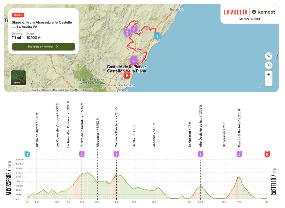

There is always more than one journey hidden inside a cycling stage. The first is the one we watch: riders attacking and chasing, gaps opening and closing, gradients rising on the screen and the number of kilometres to the finish slowly falling towards zero. The second journey is easier to miss because it lies around the peloton, in the mountains, villages and monuments that appear for a few seconds behind the race before disappearing from view.
Stage 6 of the 2026 Vuelta a España is particularly rich in those stories. From Alcossebre to Castelló, the race travels between the Mediterranean and the mountains of the Castellón interior, crossing a landscape inhabited and contested for thousands of years. Prehistoric hunters painted themselves on the walls of rock shelters here; Romans built one of the great roads of Hispania; Muslim fortresses later became Christian strongholds; coastal towers watched the sea for approaching enemies; wealthy families transformed Benicàssim into an elegant resort; and Carmelite friars sought isolation in the mountains where the decisive climb of today’s stage now waits.
The television cameras will follow the riders. Every now and then, it is worth looking around them.
-177 to -171 km · Serra d’Irta Natural Park

The Vuelta begins beside the Mediterranean at Alcossebre, with the Serra d’Irta rising immediately behind the coast. The range runs almost parallel to the sea and preserves something that has become increasingly unusual along Spain’s Mediterranean shoreline: kilometres in which mountains, cliffs, coves and Mediterranean vegetation reach the water without an almost continuous wall of urban development between them.
The landscape also carries traces of a time when the Mediterranean was not simply a source of trade, fishing and travel, but a direction from which danger could arrive. Watchtowers were constructed along this coast to observe the sea and warn communities of attacks, creating a defensive network whose remains still punctuate the mountains and shoreline. It is a fitting introduction to the stage because the relationship between sea and mountain established here will follow the peloton for much of the day.
-171 km · Castle of Xivert, Alcalà de Xivert

Only a few kilometres after leaving Alcossebre, the race reaches Alcalà de Xivert, while high above the town the Castle of Xivert occupies a ridge overlooking the surrounding country. Its position tells much of its story before the ruins themselves do: whoever controlled this height could observe the routes connecting the Mediterranean coast with the interior.
Xivert developed as an important Muslim fortress and settlement during the Middle Ages, and significant elements of its Islamic fabric survive within the complex. The political world around it changed dramatically during the Christian expansion into the region in the 13th century, after which the castle became associated with the Knights Templar, the military order whose network of fortresses and possessions stretched across medieval Europe and the eastern Mediterranean. The result is not simply another ruined castle above a Spanish town, but a place where different periods of medieval Iberian history remain physically layered on the same mountain.
Alcalà de Xivert also gives the stage its first direct connection between place and cycling history. Vicente Iturat, born here in 1928, became a professional rider during the 1950s and early 1960s, winning four stages of the Vuelta a España and taking the points classification in 1957. More than six decades after his professional career ended, the Vuelta once again passes through the hometown of a rider who once won on its roads.
-156 to -125 km · Valltorta-Gasulla Prehistoric Rock Art
As the race moves inland through Les Coves de Vinromà towards Albocàsser, it enters the cultural landscape of Valltorta-Gasulla, where limestone ravines conceal some of the most remarkable prehistoric rock art in eastern Spain. The shelters found throughout this territory form part of the UNESCO-listed Rock Art of the Mediterranean Basin on the Iberian Peninsula, an immense collection of prehistoric sites extending across the eastern side of the country.
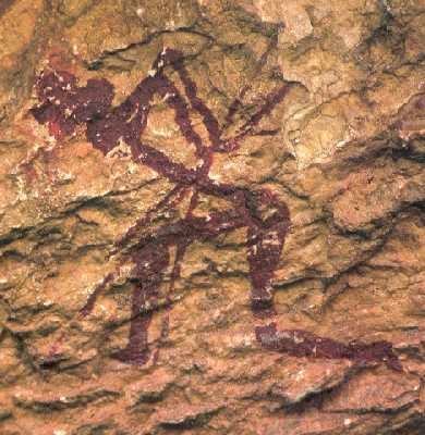
What survives on these walls is compelling because it is recognisably human. Figures hunt with bows, animals move across the rock, groups of people appear together and bodies are represented with an economy of line that nevertheless preserves a striking sense of action. They are scenes left by communities whose names and languages have vanished, but whose understanding of movement, hunting and social life can still be glimpsed thousands of years later.
A cycling race provides an unusual perspective from which to encounter them. We understand a stage through movement across territory, following human beings from one point on a map to another and measuring their progress kilometre by kilometre, yet people were already travelling through these same valleys and recording their lives here long before roads, towns or organised sport existed. Of everything the peloton passes today, Valltorta reaches furthest into the human past.
-125 km · Sant Pau d’Albocàsser
The race reaches Albocàsser deep in the Castellón interior, where the landscape bears little resemblance to the Mediterranean resort from which the stage began. Agriculture, stone buildings, scattered settlements and the dry terrain of the Maestrat dominate here, creating a world historically shaped by the difficulty of moving and surviving between relatively isolated communities.

Nearby stands Sant Pau d’Albocàsser, a historic hermitage and hospedería that developed as a place of religious devotion and hospitality for travellers. Its interest lies not only in the architecture but in what the complex represents: a countryside once crossed by pilgrims, merchants and local people moving between villages at a pace completely different from the peloton passing through today. The modern race covers this territory in minutes, but Sant Pau belongs to a period when crossing the same landscape was itself a significant part of the journey.
-84 km · Roman Arch of Cabanes and the Via Augusta
Near Cabanes, the history of travel through this landscape becomes almost literal. The Roman Arch of Cabanes, probably constructed during the Roman imperial period as part of a funerary monument, survives beside the corridor followed by the Via Augusta, the great road that ran along much of the Mediterranean side of the Iberian Peninsula.

The Via Augusta connected cities, ports and settlements across Roman Hispania and linked them with the wider communications network of the empire. Soldiers, administrators, merchants, travellers, goods and information moved along this corridor centuries before the modern roads beneath the Vuelta existed, making Cabanes one of the most appropriate discoveries of the entire stage. Nearly two thousand years separate the Roman traveller from the professional cyclist, yet both journeys are shaped by the same geographical problem: finding the most effective way through the mountains and along the Mediterranean coast.
For a race built around roads, there is something particularly satisfying about encountering the remains of one of antiquity’s great road systems with roughly 84 kilometres still to race.
-66 km · Oropesa Castle and Torre del Rey
When the peloton reaches Oropesa del Mar, the Mediterranean returns to view. Two very different fortifications tell the story of the town’s strategic importance: the medieval Oropesa Castle, whose ruins stand on high ground overlooking the settlement, and the Torre del Rey, a later defensive tower much closer to the shoreline.
Oropesa Castle belonged to the medieval world of fortified towns and shifting frontiers between Muslim and Christian powers. The surrounding region was contested during the centuries of Christian expansion into eastern Iberia and was also connected with the campaigns of Rodrigo Díaz de Vivar, El Cid, who operated across this politically fragmented landscape in the late 11th century.

The Torre del Rey, by contrast, tells a later and more specifically maritime story. Standing near the sea, the massive stone tower was developed to protect Oropesa against attacks arriving from the Mediterranean, particularly the threat of corsair raids that repeatedly endangered settlements along the Valencian coast.
Together, the two monuments reveal different layers of Oropesa’s defensive history: the castle guarded the medieval settlement and surrounding territory from its elevated position, while the Torre del Rey helped defend the coast from threats arriving by sea. What today appears to the peloton as an inviting Mediterranean resort was, for centuries, a strategically exposed frontier that had to be watched and defended.

-60 km · Ruta de las Villas, Benicàssim
Only a few kilometres farther along the coast, Benicàssim introduces a completely different chapter. From the late 19th century into the early decades of the 20th, wealthy families began constructing elaborate summer residences beside the Mediterranean, transforming part of the shoreline into a fashionable retreat whose surviving houses are now known collectively as the Ruta de las Villas.

The villas belong to a world of bourgeois leisure, seaside promenades and architectural display that feels far removed from the fortresses and watchtowers encountered only kilometres earlier. Their presence also demonstrates how profoundly the meaning of the Mediterranean coast changed over time: a shoreline once defended against enemies arriving from the sea became a place to which affluent families deliberately escaped for relaxation. Within little more than one hundred kilometres of racing, the Vuelta has moved from prehistoric shelters and Roman infrastructure through medieval frontier country to the beginnings of modern Mediterranean tourism.
-60 km · Festival Internacional de Benicàssim
Benicàssim’s international identity did not end with its villas. Since the 1990s, the town has also been associated with the Festival Internacional de Benicàssim, better known as FIB, which developed into one of Spain’s best-known music festivals and brought major international rock, indie and electronic artists to this relatively small Mediterranean community.

It is an unexpected connection when encountered through a Grand Tour route, but that is precisely why it belongs here. A town that appears on the Vuelta map because the peloton happens to race through it has simultaneously been a Belle Époque resort and, generations later, a destination for enormous crowds arriving for music rather than cycling. The road remains the same while the reasons people gather beside it continue to change.
-57 to -21 km · Desert de les Palmes Natural Park

Behind Benicàssim rises the Desert de les Palmes, one of the defining landscapes of the stage and a place whose name immediately creates the wrong image. There are no great dunes waiting above the Mediterranean, because the word deserthere belongs not to geography but to religion. Within the tradition of the Discalced Carmelites, a desert was an isolated place chosen for prayer, contemplation and withdrawal from ordinary life, and Carmelite communities sought precisely that solitude in these mountains.
Their presence became part of a landscape already shaped by steep ridges, Mediterranean forest and extraordinary views towards the sea. The natural park today preserves both this environment and traces of its religious history, meaning that the mountains through which the Vuelta now races were once deliberately chosen because they seemed sufficiently remote from the world below. Benicàssim and its crowded beaches lie only a short distance away, yet from higher in the range the character of the landscape changes completely.
The contrast could hardly be better suited to the stage. The peloton leaves a coastal town famous for villas, tourism and music and, within kilometres, enters mountains historically valued for silence and isolation.
-24 km · El Bartolo Unpaved Sector
As the race approaches its decisive final ascent, even the surface beneath the riders changes. The route towards El Bartolo includes approximately 1.9 kilometres of unpaved road, introducing dirt and loose material into a stage that has already accumulated considerable climbing before reaching this point.

The sporting consequences are obvious, particularly late in the race when positioning, traction and mechanical reliability matter most, but the sector also belongs naturally to the story of the landscape. Modern professional cycling usually depends upon an extraordinarily controlled road environment, with asphalt allowing riders to descend and corner at speeds unimaginable to earlier travellers. Here, briefly, that certainty disappears and the mountain road itself becomes visible as something physical and imperfect rather than merely the surface on which the competition happens.
-21 km · El Bartolo, Desert de les Palmes Viewpoint
The final major climb reaches El Bartolo, one of the highest and most recognisable points of the Desert de les Palmes. For the Vuelta it is a Category 1 ascent of approximately 9.4 kilometres at an average gradient of 7.1 percent, a set of numbers that will determine tactics, attacks and perhaps the result of the stage. The mountain, however, has a story independent of what happens on its slopes today.

From its heights the Mediterranean coastline opens below, while the surrounding ridges reveal why the Carmelites considered these mountains suitable for retreat. El Bartolo belongs simultaneously to the natural geography of Castellón, the religious landscape of the Desert de les Palmes and, after repeated encounters with cycling, to the sporting geography of the region as well. Few points on the stage bring those different worlds together so clearly.
Once the riders cross the summit, only the descent and the run towards Castelló remain. The mountains that have shaped most of the day finally begin to release the peloton towards the finish.
FINISH · Castelló de la Plana and El Fadrí
The race ends in Castelló de la Plana, where the city’s most recognisable monument, El Fadrí, rises beside the Concatedral de Santa María. Built over a long period between the 15th and 17th centuries, the octagonal freestanding bell tower became the architectural symbol of Castelló and provides an appropriate final landmark after a stage in which towers, castles and mountains have repeatedly appeared above the road.

Castelló’s story also extends through people who carried the city’s name far beyond the region. Matilde Salvador, born here in 1918, became one of the significant Valencian composers of the 20th century, creating operatic, choral and orchestral works while maintaining a particularly strong relationship with Valencian language and culture. Sergio Aragonés, born in Castelló in 1937 before spending his childhood across Europe and Mexico, followed an entirely different path and became one of the most recognisable cartoonists associated with American MAD magazine, developing a visual style understood by readers regardless of language.
By the time the winner crosses the line, television will have recorded 177.5 kilometres of racing between Alcossebre and Castelló. Around that race, however, the peloton will have travelled through a human landscape stretching from prehistoric hunters to Roman engineers, medieval warriors, Carmelite friars, composers, artists and the millions of ordinary people who have lived beside these roads without ever imagining that one day the Vuelta a España would come racing past their door.



