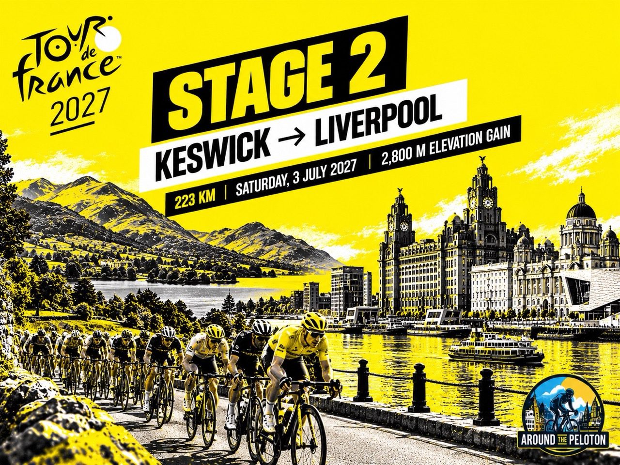


The second stage of the 2027 Tour de France takes the peloton from the mountains of the Lake District to Liverpool’s historic waterfront, crossing landscapes that witnessed some of the most profound cultural and economic changes in British history. Between the literary world of Keswick and the industrial towns of Lancashire, five categorised climbs and 223 kilometres of racing could turn an apparently straightforward finish into a contest of endurance, tactical judgement and survival.
Stage 2 | Saturday, 3 July 2027 | Keswick → Liverpool | 223 km | Approximately 2,800 m elevation gain
In the early nineteenth century, the mountains surrounding Keswick became a refuge for writers who found in the Lake District a landscape seemingly removed from the industrial transformation gathering pace across Britain. Samuel Taylor Coleridge and William Wordsworth helped establish the region as a centre of Romantic literature, celebrating the relationship between nature, imagination and human experience while, farther south, the factories of Lancashire were drawing thousands of workers into rapidly expanding towns. Yet these two worlds were never entirely separate. The prosperity generated by industrialisation helped bring new visitors to the lakes, while the railways that connected northern England’s manufacturing centres eventually transformed the region into one of the country’s most popular destinations.
On 3 July 2027, the Tour de France will travel through this historical geography, leaving Keswick for Liverpool on a 223-kilometre journey that crosses the landscapes of Romantic England, the uplands of Lancashire and the industrial heartland that helped build Britain’s maritime economy. The route passes through Lancaster, climbs into the Forest of Bowland and continues through Blackburn and the former textile districts before approaching the River Mersey, where Liverpool’s waterfront provides a finish closely associated with the country’s commercial and cultural history.
The sporting challenge is considerable. Five categorised climbs punctuate the route, three of them concentrated within a short section of the Bowland hills, while approximately 2,800 metres of elevation gain make the stage substantially more demanding than its relatively flat conclusion might suggest. After the opening day from Edinburgh to Carlisle, the peloton faces a longer and more selective test in which the strongest sprinters may have to defend their chances against attackers who see the Lancashire hills as an opportunity to disrupt the expected finish.
–223 km | Keswick: The Mountains That Changed Britain’s Imagination
Keswick stands at the northern end of Derwentwater, surrounded by the mountains of the northern Lake District and overlooked by Skiddaw, whose broad summit rises above the town. The setting has attracted generations of travellers, although the landscape’s modern reputation as a place of beauty and recreation conceals a much older history of agriculture, mining and commerce. Keswick developed as a market town serving the surrounding valleys, while mineral extraction became an important part of the local economy during the sixteenth century, when skilled miners from continental Europe contributed to the development of copper mining in the area. The mountains that later inspired poets were therefore never untouched wilderness; they were working landscapes whose inhabitants had long adapted their livelihoods to the opportunities and difficulties of the surrounding terrain.

The town’s literary reputation developed during the Romantic period, when writers began to challenge established attitudes towards mountain scenery and the natural world. Samuel Taylor Coleridge moved to Greta Hall in Keswick in 1800, maintaining a close intellectual and personal relationship with William Wordsworth, who lived farther south at Grasmere. Their poetry explored memory, imagination and the emotional significance of ordinary experience, drawing inspiration from a landscape that earlier travellers had sometimes regarded as forbidding or unproductive. The Lake District became more than a picturesque setting for their work: it offered a way of questioning the values of an increasingly commercial and industrial society, even as the poets themselves remained closely connected to the political and intellectual debates of their age.
Wordsworth’s influence extended beyond literature, helping establish the region as a destination for visitors who wished to encounter the scenery described in his writing. The development of tourism gradually changed the local economy, bringing inns, transport services and new commercial opportunities to communities that had traditionally depended on farming and extractive industries. By the nineteenth century, the Lake District was becoming a place where the growing urban population of northern England could seek recreation and a sense of distance from industrial life, although the expansion of tourism also brought new pressures on the landscape and its inhabitants.
The Tour’s departure from Keswick places the riders within this long history of changing relationships between people and the natural environment. The mountains surrounding the town provide an imposing backdrop, but the route initially follows the valleys south rather than climbing towards the highest summits, allowing the race to move through some of the Lake District’s most celebrated scenery before the more demanding terrain of Lancashire begins.
–194.5 km to –147 km | Windermere and the Roads That Opened the Lake District
The opening section carries the peloton south through the Lake District towards Windermere, reached at –194.5 km, following a landscape shaped by glaciers that carved deep valleys between the surrounding mountains. Lakes occupy the lower ground, while farms, villages and historic routes reflect centuries of settlement in a region where geography has always influenced movement. Although the scenery is closely associated with the Romantic poets, its appearance also owes much to generations of agricultural activity, particularly sheep farming, which helped shape the open character of the fells and the patchwork of fields in the valleys.

When the railway reached Windermere in 1847, it did more than make a remote landscape accessible to a growing number of visitors; it changed the relationship between the Lake District and the industrial towns to its south. Railway passengers could leave the streets of Manchester or Liverpool and reach the mountains and lakes within a journey that earlier generations would have found far more difficult and expensive. The transformation carried an irony that Wordsworth, who had expressed reservations about railway expansion into the region, would have recognised. The industrial society from which visitors sought temporary escape was providing the means for their arrival, while the landscape celebrated for its apparent separation from modern life became increasingly dependent on the economy and infrastructure of that same society.
Tourism brought prosperity to local businesses but also changed the character of communities that had traditionally relied on farming, mining and local trade. Hotels, transport services and visitor attractions developed alongside older activities, while the growing popularity of the Lake District encouraged debates about access, conservation and the effects of commercial development on the natural environment. Those tensions remain part of the region’s history, illustrating how the desire to preserve a landscape can exist alongside the economic pressures created by its popularity.
As the peloton approaches Milnthorpe at –170.5 km, the mountains gradually recede and the countryside begins to open towards the lower ground surrounding Morecambe Bay. The journey continues through a landscape where agricultural settlements and market towns developed along routes connecting southern Cumbria with Lancashire, before reaching Carnforth at –157.5 km. Here the railway’s influence becomes visible in a different form: Carnforth developed as an important junction in northern England’s expanding transport network, its station later acquiring a place in British cinema through David Lean’s 1945 film Brief Encounter.
The passage from Windermere to Carnforth illustrates how transport gradually dissolved some of the barriers imposed by northern England’s geography. Railways brought tourists into the Lake District, connected rural communities with larger markets and linked the industrial towns of Lancashire to the ports through which their goods travelled. By the time the riders reach Lancaster at –147 km, the stage has moved beyond the mountains that defined its opening kilometres and into a region where commercial history, upland geography and the legacy of industrialisation become increasingly prominent.
–147 km | Lancaster: Commerce, Empire and the Gateway to Bowland

Lancaster developed beside the River Lune, close enough to the Irish Sea to benefit from maritime connections while occupying a strategic position on routes through northwestern England. The Romans recognised the importance of the location, establishing a military presence that preceded the medieval town, whose subsequent development centred on its castle, market and commercial activities. Lancaster Castle remains one of the city’s most prominent landmarks, reflecting centuries of defensive and judicial history, including its association with the Pendle witch trials of 1612. The trials, which resulted in ten executions, became one of the most notorious episodes in English witchcraft prosecutions and continue to shape the historical identity of the surrounding region.
During the eighteenth century, Lancaster’s merchants participated in expanding Atlantic trading networks, including the trafficking of enslaved Africans and commerce in goods produced through enslaved labour. The wealth generated through these activities contributed to the town’s prosperity and left an architectural legacy that must be understood alongside the human exploitation on which parts of that economy depended. Although Lancaster eventually lost ground to larger ports, particularly Liverpool, its commercial history reveals how towns across northern England became connected to overseas markets long before the Industrial Revolution reached its full intensity.

The Tour leaves this historic trading centre and turns towards the Forest of Bowland, where the landscape becomes increasingly rural and elevated. Despite its name, Bowland is not predominantly covered by trees; the term forest reflects its medieval status as a hunting territory, while much of the present landscape consists of open moorland, grass-covered fells, river valleys and isolated farms. Sheep farming has long been an important activity in the region, and the relatively sparse settlement reflects the difficulties of cultivating its higher ground. The hills lack the dramatic rocky summits of the Lake District, but their exposed roads and persistent gradients present a different challenge, particularly when encountered at racing speed.
For the peloton, the approach to Bowland marks the beginning of the stage’s most concentrated climbing. The first 76 kilometres have carried the riders through a succession of valleys and relatively gentle roads, but the following section contains three categorised ascents within 24 kilometres, creating an opportunity for aggressive riders to test the strength and organisation of the sprint teams.
–135 km | Jubilee Tower: A Victorian Monument Above Lancaster
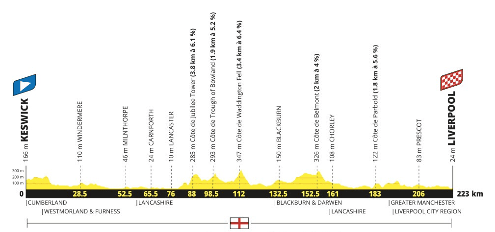
Jubilee Tower climb — 3.8 km at 6.1%
The first categorised ascent leads towards Jubilee Tower, a monument erected in 1887 to commemorate Queen Victoria’s Golden Jubilee. Standing on high ground above Lancaster, the tower overlooks the surrounding countryside and Morecambe Bay, its position reflecting the Victorian enthusiasm for public monuments that celebrated the monarchy and Britain’s imperial prominence. The landscape beneath it has changed considerably since the nineteenth century, but the monument remains a distinctive landmark on the road into the Bowland hills.

The climb measures 3.8 kilometres at an average gradient of 6.1%, making it the longest categorised ascent of Stage 2. Its summit comes after 88 kilometres of racing, sufficiently early to encourage attacks without immediately threatening the overall contenders. Riders interested in the mountains classification will have an obvious reason to contest the ascent, particularly if they have joined the day’s early breakaway, while teams hoping to deliver a sprinter to Liverpool must decide how much energy to spend controlling the pace.
Jubilee Tower also presents the first important tactical decision for the teams responsible for a possible sprint finish. Attempting to control every acceleration through Bowland could require a substantial expenditure of energy, particularly if several teams without leading sprinters place riders in the breakaway. Allowing a manageable group to establish itself may be preferable, but the composition of that group will determine how much freedom it can safely receive. If several strong riders escape together and their teams refuse to contribute to the chase, the burden of controlling the race could fall on only a handful of squads, forcing them to begin their pursuit more than 130 kilometres from Liverpool.
The road continues across the Bowland uplands, where another categorised ascent follows after just 10.5 kilometres. Riders who have struggled on Jubilee Tower may have little opportunity to recover before the next climb, while those already in the breakaway can use the succession of gradients to maintain pressure on the peloton.
–124.5 km | Trough of Bowland: The Quiet Roads of Lancashire’s Uplands
Trough of Bowland climb — 1.9 km at 5.2%
The Trough of Bowland is among Lancashire’s best-known upland routes, passing through a narrow valley surrounded by open moorland, grass-covered hills and scattered farms. Its relative isolation has helped preserve a landscape in which agriculture remains visible, with sheep grazing on the higher ground and small communities occupying the more sheltered valleys. The road has become popular with recreational cyclists because of its scenery and challenging gradients, although its quiet character will be transformed when the Tour de France arrives.

The categorised ascent measures 1.9 kilometres at an average gradient of 5.2%, a modest challenge when considered in isolation but one that gains importance from its position immediately after Jubilee Tower. Riders who have been forced to chase following the first climb may find themselves under pressure again before they have fully recovered, while those already in the breakaway can use the succession of gradients to maintain their advantage. The terrain encourages changes of pace, particularly where the road rises out of the valley, making it difficult for a large group to maintain the steady rhythm preferred by teams protecting their sprinters.
The Trough of Bowland also provides a reminder that the geography of professional cycling is not defined exclusively by high mountains. Short climbs can become tactically important when they occur in rapid succession, especially during a long stage in which fatigue accumulates gradually. With Waddington Fell still ahead, the peloton must negotiate the second ascent without knowing whether the most demanding part of the sequence will produce a significant selection.
–111 km | Waddington Fell: The Highest Point of the Stage
Waddington Fell climb — 3.4 km at 6.4%
Waddington Fell rises above the Ribble Valley, where the eastern reaches of Lancashire’s upland landscape open towards the surrounding countryside. The climb reaches approximately 347 metres above sea level, making it the highest marked point on the Stage 2 profile, while its average gradient of 6.4% is the steepest of the three categorised ascents through Bowland. Although the elevation is modest compared with the major climbs of the Tour de France, the road offers a sustained effort at a point when the riders have already negotiated two other categorised hills within a relatively short distance.
The summit comes after 112 kilometres, almost exactly halfway through the stage, and provides a natural point at which the effects of the preceding climbs may become apparent. A peloton that has maintained a controlled pace could remain largely intact, allowing the sprint teams to continue their pursuit towards Liverpool, but repeated accelerations may have created gaps that prove difficult to close. Riders who have spent energy returning after Jubilee Tower or the Trough of Bowland could find themselves exposed again, while stronger climbers may see an opportunity to establish a more decisive advantage.

For teams built around a fast finisher, Waddington Fell provides an opportunity to assess whether their original strategy remains realistic. If their sprinter has survived the climbs comfortably and enough domestiques remain available, they may choose to increase the pace on the following roads and begin reducing the breakaway’s advantage. If the team has lost important riders, however, an immediate pursuit could be counterproductive, leaving the leader isolated before the final kilometres. The decision will also depend on the interests of rival squads, since a chase shared between several teams is considerably less costly than one maintained by a single organisation.
The Bowland sequence ends with more than 100 kilometres still to race, an important distinction from mountain stages where a final ascent can determine the result almost immediately. Any selection created on Waddington Fell must survive a long journey through Lancashire, including two further categorised climbs and a relatively flat approach to Liverpool. The principal consequence of the three ascents may therefore be less visible than an immediate attack: the redistribution of strength between teams, which could influence the race long after the hills themselves have disappeared behind the peloton.
Beyond the summit, the route moves away from the most remote upland country and towards Blackburn, where the history of northern England becomes inseparable from the industrial transformation that reshaped the region during the eighteenth and nineteenth centuries.
–90.5 km | Blackburn: Cotton, Industry and the Making of Modern Lancashire

Blackburn became one of Britain’s major cotton-manufacturing centres during the Industrial Revolution, its growth reflecting the extraordinary expansion of mechanised textile production across Lancashire. The town had long been associated with textile work, but the development of factories and improvements in machinery transformed the scale of production, drawing workers from surrounding communities and encouraging rapid urban expansion. Mills, workshops and workers’ housing spread across the town, while the rhythms of daily life became increasingly governed by industrial employment rather than the seasonal demands of agriculture.
The prosperity of Blackburn’s cotton industry depended on commercial networks extending far beyond Lancashire. Much of the raw cotton processed in the region during the nineteenth century came from plantations in the American South, where enslaved labour underpinned production before the abolition of slavery in the United States. The cotton travelled through ports such as Liverpool before reaching inland manufacturing towns, where it was transformed into cloth for domestic consumption and export. Canals and railways helped connect these different stages of production, creating an industrial system in which maritime trade, manufacturing and transport became mutually dependent.
Industrial growth brought wealth and technological development, but it also imposed considerable costs on the people whose labour sustained it. Factory workers endured long hours and difficult conditions, while overcrowded housing, pollution and economic insecurity accompanied the expansion of the mills. The dependence on overseas supplies became particularly apparent during the American Civil War, when disruptions to cotton imports contributed to the Lancashire Cotton Famine of the 1860s. Blackburn and other manufacturing towns experienced widespread unemployment and hardship, revealing the vulnerability of communities whose livelihoods depended on political and economic events thousands of kilometres away.

The Tour’s passage through Blackburn therefore connects the rural landscapes of Bowland with the industrial economy that helped transform northern England. The contrast is not simply between countryside and town, but between different forms of labour and settlement that developed within a relatively small geographical area. While the uplands supported farming communities whose activities changed gradually over centuries, Blackburn experienced rapid expansion driven by global commerce, technological innovation and the demand for manufactured goods.
For the riders, the principal Bowland climbs are now behind them, although the stage remains demanding. The route continues through the higher ground of Lancashire before approaching the final categorised ascent near Parbold, leaving the teams responsible for controlling the race to assess how much strength they have retained after the opening 130 kilometres.
–70.5 km | Belmont: Across the West Pennine Moors
Belmont climb — 2 km at 4%
The fourth categorised ascent takes the peloton towards Belmont, a village situated among the hills of the West Pennine Moors, where open uplands, reservoirs and scattered settlements occupy the higher ground between Lancashire’s former industrial towns. The landscape differs from the broad valleys and exposed fells of Bowland, with a succession of rounded hills and artificial lakes creating a distinctive upland character. The reservoirs are among its most recognisable features, their waters occupying valleys that were altered through engineering projects undertaken during the nineteenth and twentieth centuries.

The roads around Belmont are familiar to cyclists from the surrounding towns, offering climbs that are relatively short but often exposed to changing weather conditions. The ascent selected for Stage 2 measures 2 kilometres at an average gradient of 4%, making it less demanding than the earlier climbs through Bowland, although its position after more than 150 kilometres of racing gives it a significance beyond the numbers. Riders who have already struggled on the previous ascents may find even moderate gradients difficult to manage, particularly if the pace remains high, while those still pursuing a breakaway must balance the need to maintain speed against the effort required for the final approach.
The route subsequently continues towards Chorley at –62 km, passing through a part of Lancashire where industrial settlements and agricultural countryside have long existed in close proximity. The higher ground gradually gives way to the lower landscape of West Lancashire, although the riders must still negotiate one final categorised climb before reaching the roads that lead towards Liverpool.
–40 km | Parbold: The Last Obstacle Before the Mersey
Parbold climb — 1.8 km at 5.6%
Parbold lies in West Lancashire, where the hills gradually give way to the lower countryside approaching Liverpool. The village developed near the River Douglas and later became connected to the Leeds and Liverpool Canal, an ambitious engineering project that helped link Lancashire’s industrial districts with the port through which many of their goods travelled. Construction began in the eighteenth century, and the canal eventually became part of the transport infrastructure that supported the region’s manufacturing economy, carrying raw materials and finished products between inland communities and commercial centres.

The Tour’s final categorised climb measures 1.8 kilometres at an average gradient of 5.6%, with its summit reached after 183 kilometres of racing. The ascent is short enough for many sprinters to survive under favourable conditions, but its position makes it an important test of accumulated fatigue. Riders who have spent much of the day following attacks or returning to the peloton may find themselves vulnerable, while those seeking to escape can use the gradient to force another acceleration before the road becomes more favourable to organised pursuit.
The remaining 40 kilometres create an interesting tactical balance. Parbold is close enough to Liverpool to encourage a late move, particularly if the main group has already been reduced, yet far enough from the finish to give the sprint teams time to respond. A well-organised peloton should be capable of bringing back a manageable advantage on the flatter roads towards the city, but that calculation changes if the teams behind the breakaway no longer share the same objectives.
If several sprinters have been dropped, their teams may have little incentive to contribute to the chase, while squads represented in the leading group will naturally prefer to protect their advantage. The responsibility could then fall on a small number of teams, creating opportunities for attackers who have preserved enough strength to maintain a high pace over the final kilometres. Conversely, if several sprint squads remain intact and committed to a mass finish, the terrain beyond Parbold should favour their collective pursuit.
The climb may therefore influence the outcome without producing the winning attack itself. Its position provides a final opportunity to test the peloton’s organisation, while the composition of the group leaving the summit could determine whether the race develops into a conventional sprint or remains open to late aggression.
Beyond Parbold, the stage leaves the final significant hills behind and approaches the increasingly urban landscape of the Liverpool City Region. The riders have travelled through the Lake District, crossed the Bowland uplands and passed the industrial towns of Lancashire; the final kilometres now carry them towards the port that connected much of this region’s economic activity with the wider world.
–17 km | Prescot: Skilled Crafts and the Approach to Liverpool
Prescot, reached with approximately 17 kilometres remaining, developed as a market town before acquiring an important reputation for watchmaking during the eighteenth and nineteenth centuries. Its workshops specialised in watch movements and components, creating a network of skilled craftsmen whose products circulated well beyond the town itself. The industry illustrates the diversity of manufacturing in Lancashire, where cotton dominated many communities but other towns developed specialised trades requiring precision, technical knowledge and cooperation between small workshops.
The town also has a place in the history of English theatre, with evidence of dramatic performances during the Elizabethan period contributing to renewed interest in its cultural past. The Shakespeare North Playhouse, which opened in 2022, reflects that heritage and has brought a modern theatrical venue to a community whose historical identity extends beyond its industrial activities.
As the peloton passes through Prescot, the demands of the stage begin to change. The categorised climbs are complete, and the remaining roads are comparatively flat, allowing the surviving sprinters and their teams to prepare for the finish. Yet after more than 200 kilometres of racing, the ability to organise an effective lead-out will depend on how much energy has been spent across the hills of Lancashire. A team that appeared strong at the start in Keswick may have lost important riders during the Bowland sequence, while a more versatile squad could arrive in Liverpool with greater freedom to control the final kilometres.
The approach to the city could become particularly complicated if a breakaway remains ahead, since the teams responsible for the pursuit must decide how long to maintain their effort before preparing for the finish itself. Riders with ambitions of a late attack may also attempt to exploit hesitation within a reduced peloton, particularly if the remaining sprint teams are reluctant to commit their final domestiques too early. The finish lies beside a waterfront whose history provides the final connection in the stage’s journey through northern England.
FINISH | Liverpool: The Port That Connected Industrial Britain to the World
Liverpool’s rise from a relatively small medieval settlement into one of the world’s great maritime cities was driven by its position on the River Mersey and its growing involvement in Atlantic commerce. Although the town received its borough charter in 1207, its most dramatic expansion came during the eighteenth and nineteenth centuries, when shipping, trade and industrial development transformed its economy and urban landscape. The docks became a gateway through which goods, people and capital moved between Britain and the wider world, creating commercial relationships that extended across Europe, Africa, the Americas and beyond.

That prosperity was inseparable from Liverpool’s involvement in the transatlantic slave trade. During the eighteenth century, the city became one of Britain’s principal ports for ships engaged in the forced transportation of enslaved Africans, while merchants and businesses benefited from the wider economy of plantation slavery. The wealth accumulated through these activities contributed to Liverpool’s development, leaving a legacy that forms an essential part of the city’s history. Understanding its rise as a commercial centre requires recognising both the scale of its maritime achievements and the exploitation on which significant parts of that wealth depended.
During the nineteenth century, Liverpool’s importance grew alongside the industrial expansion of Lancashire and the wider north of England. Cotton arriving from overseas was transported inland to manufacturing towns such as Blackburn, where it was processed into cloth before returning through commercial networks for distribution and export. Railways, canals and improved docks made these movements increasingly efficient, connecting the factories of northern England with international markets and helping establish Liverpool as one of the principal ports of the industrial age.

The city’s waterfront preserves an architectural record of that commercial prominence. The Royal Liver Building, Cunard Building and Port of Liverpool Building, collectively known as the Three Graces, stand as symbols of the wealth and confidence generated by maritime trade. Their imposing façades overlook the Mersey, where generations of ships carried passengers and cargo to destinations across the world, while the surrounding docklands have undergone extensive transformation as Liverpool’s economy has changed.
Migration was equally important in shaping the city’s identity. Large numbers of Irish migrants settled in Liverpool, particularly during and after the Great Famine of the 1840s, contributing to a distinctive urban culture influenced by the city’s connections with Ireland and the wider Atlantic world. During the twentieth century, those international influences helped create a rich musical environment from which the Beatles emerged, bringing Liverpool global cultural recognition that extended far beyond its traditional maritime economy. Football became another defining element of local identity, with Liverpool and Everton developing histories and rivalries that remain central to the city’s sporting culture.
The Tour’s arrival beside the Mersey therefore concludes a journey through several interconnected chapters of British history. The literary landscapes of the Lake District, the commercial traditions of Lancaster, the cotton mills of Blackburn and the port of Liverpool were all shaped by the movement of people, goods and ideas across northern England. Their histories developed in different ways, but the roads and transport networks connecting them helped create the economic and cultural landscape through which the peloton will travel.

The race also brings renewed attention to a regional cycling tradition that has already produced one of Britain’s most influential Tour de France competitors. Across the Mersey from Liverpool, a young rider from the Wirral developed the exceptional ability against the clock that would eventually carry him into the yellow jersey and help change the international reputation of British cycling.
Chris Boardman: A Merseyside Rider Who Changed British Cycling
Chris Boardman grew up on the Wirral, across the River Mersey from Liverpool, and emerged as one of Britain’s leading cyclists during a period when the country had yet to establish the sustained international success it would enjoy in later decades. His career combined exceptional physical ability with an unusually systematic approach to equipment, aerodynamics and preparation, making him one of the defining figures in the development of modern time-trial cycling. At the 1992 Barcelona Olympics, he won gold in the individual pursuit, becoming Britain’s first Olympic cycling champion for 72 years and drawing attention to the distinctive Lotus bicycle on which he achieved the victory.
Boardman’s most significant Tour de France breakthrough came in 1994, when he won the opening prologue in Lille and became the first British rider to wear the yellow jersey since Tom Simpson in 1962. His performance demonstrated the precision and power that had made him such a formidable competitor against the clock, while the yellow jersey gave British cycling a moment of international prominence at a time when its presence in the professional peloton remained comparatively limited. Boardman returned to win the Tour’s opening prologues in 1997 and 1998, establishing a remarkable record in the discipline and reinforcing his reputation as one of the outstanding time-trial specialists of his generation.
His achievements have remained closely associated with the Liverpool region, where the Museum of Liverpool displayed bicycles connected with his career when it opened in 2011. The recognition placed Boardman’s sporting success within the wider history of a city and region whose contributions to British culture, industry and sport extend across many fields. Liverpool has also hosted major professional road racing, including the opening stage of the 2014 Tour of Britain, won by German sprinter Marcel Kittel, although the 2027 Tour de France presents a considerably more demanding route before the riders reach the city.
Boardman’s victories were achieved through individual efforts against the clock, whereas the outcome in Liverpool may depend on the collective strength of a team capable of surviving five climbs and organising a sprint after 223 kilometres. The contrast illustrates the variety of demands within professional cycling, while providing a historical connection between the city and the yellow jersey that the Tour’s arrival will bring back into focus.
Stage 2 Prediction: A Sprint for the Strongest Survivors
Most likely outcome: a sprint from a reduced or substantially fatigued peloton.
The final 40 kilometres provide sufficient distance for the peloton to regroup, making a sprint a realistic outcome despite the five categorised climbs. Nevertheless, the concentration of ascents through the Forest of Bowland, followed by the later obstacles at Belmont and Parbold, could make the stage selective enough to eliminate some of the pure sprinters or leave their teams short of the riders needed for a conventional lead-out. A fast finisher capable of handling repeated climbs without losing too much energy may therefore be better suited to the route than a specialist who depends on a large, organised group arriving together.
A successful breakaway remains a credible alternative, particularly if the Bowland sequence produces a strong group and the teams behind struggle to cooperate over the remaining distance. The stage is long enough for fatigue to influence tactical decisions, while the repeated climbs offer opportunities for riders to exploit moments of hesitation or weakness. Without a confirmed start list, naming individual favourites would be premature, but the profile suggests that endurance and versatility could prove as important as outright sprinting speed.
For the general classification contenders, the principal objective will be to avoid unnecessary losses while remaining attentive to possible splits and changes of pace. The decisive contest for the 2027 Tour will emerge later, through its two individual time trials and the major mountain stages, but the opening weekend can still expose weaknesses in team organisation and positioning. A difficult day through Lancashire may not establish the eventual winner, yet it could reveal which riders and teams are best prepared for the demands of the race.
From the Lake District to the Mersey: Two Worlds, One History
When Coleridge settled in Keswick at the beginning of the nineteenth century, the mountains of the Lake District offered a setting in which the Romantic imagination could explore a different relationship between humanity and the natural world. Farther south, the factories of Lancashire were transforming the country through machinery, commerce and an expanding industrial workforce, while Liverpool’s docks connected that transformation to markets and communities across the Atlantic. The apparent distance between these worlds was always deceptive. The same industrial prosperity that filled Blackburn’s mills and Liverpool’s warehouses helped bring visitors to the Lake District, while railways and canals created connections that changed the lives of people throughout northern England.

The second stage of the 2027 Tour de France follows those connections across 223 kilometres, travelling from the landscapes that inspired the Romantic poets through the uplands of Bowland and the former textile districts of Lancashire before reaching the River Mersey. The journey reveals how Britain’s natural and industrial histories developed alongside one another, sometimes in conflict but never entirely independently. Even the quietest valleys and most remote hills belonged to a wider landscape shaped by agriculture, trade, technology and the movement of people.
For the riders, these historical connections will give way to the immediate demands of competition. Five categorised climbs, approximately 2,800 metres of elevation gain and a long approach to Liverpool could produce a sprint, reward an ambitious breakaway or leave a reduced peloton fighting for the stage victory. Yet as the race reaches the waterfront, the geographical contrast that defined its opening kilometres will have acquired a different meaning: the Tour will have travelled from the mountains where Romantic writers sought an alternative to industrial Britain to the port through which much of that industrial world was connected to the wider globe, revealing along the way that the two landscapes were never as separate as they first appeared.