


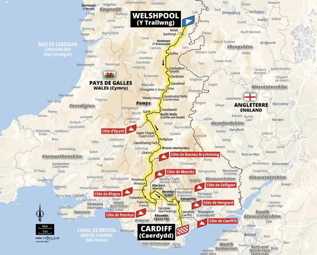
The final stage of the 2027 Tour de France Grand Départ takes the peloton across Wales, travelling from the borderlands of Powys through the mountains of Bannau Brycheiniog and into the former coalfields of South Wales. Along 223 kilometres, the riders will encounter medieval castles, Victorian spa towns, landscapes shaped by war and industry, and some of the steepest climbs of the opening week. With eight categorised ascents and a difficult final approach to Cardiff, this is a stage that could reward the specialists of the spring Classics while forcing the general classification contenders to reveal themselves earlier than expected.
Stage 3 | Sunday, 4 July 2027 | Welshpool → Cardiff | 223 km | 3,000 m elevation gain
In April 1940, farming families living on the uplands of Mynydd Epynt were told that their homes and land were required for military training. Within weeks, a Welsh-speaking community whose roots extended back generations had been scattered, its farms absorbed into a landscape that would remain under military control long after the Second World War ended. Farther south, the coal valleys were experiencing a different kind of upheaval, their communities shaped by an industry that had transformed Wales into one of the world’s great centres of energy production. These histories belong to landscapes that can appear remarkably peaceful today, yet their fields, hillsides and settlements preserve evidence of decisions and events whose consequences extended far beyond the places where they occurred.
On 4 July 2027, the Tour de France will travel through this geography on a 223-kilometre journey from Welshpool to Cardiff, crossing the agricultural heart of Mid Wales, the mountains of Bannau Brycheiniog and the former industrial valleys of the south. The route begins close to the English border before passing through market towns, Victorian spa resorts and upland communities whose histories reach back to the medieval period. As the riders approach the South Wales Valleys, the roads become shorter, steeper and more irregular, carrying the race through a succession of climbs that could transform the final day of the British Grand Départ into its first major sporting confrontation.
Wales provides a particularly rich setting for this journey because its geography has repeatedly shaped the development of its communities. Mountain ranges and river valleys influenced the boundaries of medieval kingdoms, the movement of armies and the location of market towns, while the discovery and exploitation of mineral resources brought rapid industrial expansion to the south. Throughout these changes, Welsh language, literature, music and local traditions remained important expressions of cultural identity, creating a country whose historical diversity extends well beyond the familiar images of castles, mountains and coal mines.
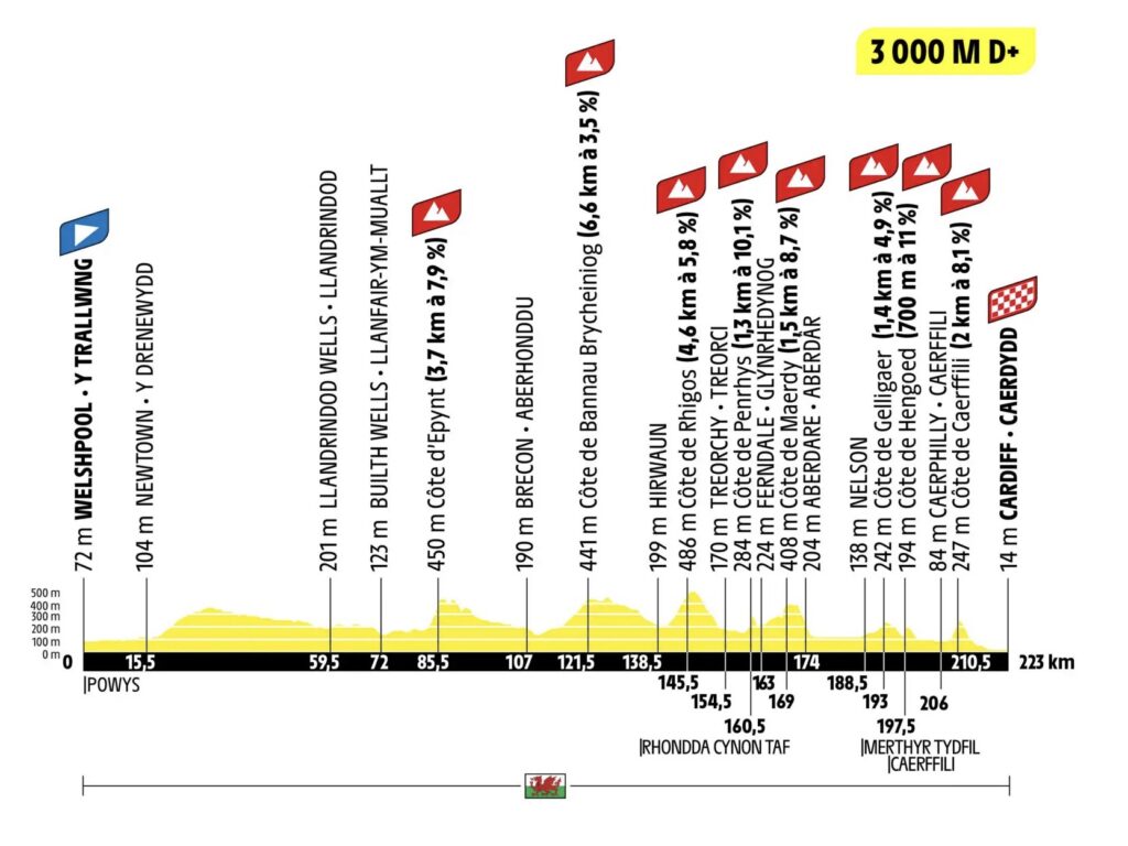
The sporting challenge is considerable. Eight categorised climbs and approximately 3,000 metres of elevation gain make Stage 3 substantially more demanding than the opening two days, while six of those ascents are concentrated within the final 80 kilometres. The last climb, the Côte de Caerffili, comes only 12.5 kilometres from the finish, giving explosive attackers an opportunity to create gaps before the peloton reaches Cardiff. The stage appears particularly well suited to riders with the characteristics of successful Ardennes Classics specialists, although the general classification contenders will also need to remain attentive throughout the difficult final section.
–223 km | Welshpool: A Border Town Beneath the Castle of Welsh Princes

(Photo: David Martin / CC BY-SA 2.0 / Source: Wikimedia Commons, File: Broad Street, Welshpool – geograph.org.uk – 8359867.jpg)
Welshpool, known in Welsh as Y Trallwng, occupies a broad section of the Severn Valley in northern Powys, only a short distance from the English border. The town developed as a market centre for the surrounding agricultural countryside, where fertile valley land and routes through the hills encouraged trade between communities on both sides of the border. Its streets reflect a long history of commercial activity, while the surrounding landscape reveals the importance of the River Severn, which begins in the mountains of Mid Wales before travelling east into England and eventually reaching the Bristol Channel.
Above the town stands Powis Castle, one of the most remarkable historic buildings in Wales. Its origins lie in the medieval Welsh principality of Powys, whose rulers struggled to maintain their independence amid the shifting political relationships between the Welsh kingdoms and the expanding power of the English crown. Unlike many castles built by the English to secure conquered territory, Powis Castle originated as a stronghold of Welsh princes, although centuries of alteration gradually transformed it from a military residence into an aristocratic country house.

(Photo: Alexander Forst-Rakoczy / CC BY-SA 2.0 AT / Source: Wikimedia Commons, File: PowisCastle.jpg)
The castle’s gardens, with their elaborate terraces, clipped yew trees and views across the Severn Valley, are among its most distinctive features. Much of their present character developed during the late seventeenth and eighteenth centuries, when formal landscaping became an important expression of aristocratic wealth and taste. Inside the castle, the Clive collection contains objects acquired in India through the family’s involvement in British imperial expansion. Robert Clive, a central figure in the East India Company’s establishment of political power in Bengal during the eighteenth century, accumulated substantial wealth through his activities in India, and his family’s collection reflects the unequal relationships through which colonial power, private fortunes and the movement of valuable objects became intertwined. The presence of these objects in a Welsh country house connects the estate to the wider history of British imperialism and raises questions about the circumstances in which individual items were obtained.
Welshpool also preserves reminders of the transport networks that once connected its agricultural economy to larger markets. The Montgomery Canal passes through the area, while the Welshpool and Llanfair Light Railway, opened in 1903, was built to serve communities in the surrounding countryside. Its surviving narrow-gauge line has become a heritage attraction, offering visitors a glimpse of the period when small railways carried goods and passengers through valleys that remained difficult to reach by road.

(Photo: Rosser1954 / CC BY-SA 4.0 / Source: Wikimedia Commons, File: Narrow boat leaving the Welshpool Canal lock on the Montgomery Canal, Powys, Wales.jpg)
The peloton begins its Welsh journey in this landscape of farms, market towns and historic transport routes, initially following relatively gentle roads south through the Severn Valley. The opening kilometres should allow the day’s breakaway to form, although the teams will already be considering the difficult terrain awaiting them farther south.
–207.5 km | Newtown: Robert Owen and the Birth of Modern Social Reform
Newtown, reached after approximately 15.5 kilometres, stands beside the River Severn and developed into one of the most important centres of woollen manufacturing in Mid Wales. During the nineteenth century, its mills produced Welsh flannel and other textiles for markets extending far beyond the surrounding countryside, while the arrival of canals and railways encouraged the expansion of trade. The town’s industrial history is particularly significant because it was the birthplace of Robert Owen, one of the most influential figures in the development of modern social reform.

Born in Newtown in 1771, Owen became a successful industrialist before acquiring an international reputation for his ideas about education, working conditions and cooperation. At the cotton mills of New Lanark in Scotland, he promoted reforms intended to improve the lives of workers and their families, arguing that human behaviour was strongly influenced by social circumstances. His experiments in industrial management and community organisation helped shape later cooperative and socialist movements, even though some of his more ambitious projects failed to achieve their intended results.
Newtown also became associated with another pioneer whose innovations anticipated modern commercial life. Sir Pryce Pryce-Jones, born nearby in 1834, developed an international mail-order business selling Welsh textiles to customers who could select goods without visiting his shop. Using the postal system and expanding railway network, he established a distribution model that allowed products manufactured in a small Welsh town to reach customers across Britain and overseas. His Royal Welsh Warehouse, opened beside the railway station in 1879, symbolised the growing relationship between industrial production, transport and consumer commerce.
The contrast between Owen and Pryce-Jones offers an unusually rich historical perspective on a town of relatively modest size. One became internationally known for questioning the social consequences of industrial capitalism, while the other demonstrated how new methods of communication and distribution could transform commercial opportunity. Their achievements emerged from the same wider world of textile production and technological change, giving Newtown a place in the history of both social reform and modern retailing.

The stage’s intermediate sprint is marked at Newtown, where the riders will contest the first available sprint points before continuing into the more demanding countryside of central Powys. From here the route leaves the Severn Valley and climbs towards Dolfor, entering a region of rounded hills, scattered farms and small settlements where agriculture has remained a defining feature of the landscape.
–163.5 km | Llandrindod Wells: The Victorian Spa in the Heart of Wales
The journey south from Newtown passes through the uplands of Radnorshire, following roads that connect isolated farming communities and small villages across the eastern reaches of Mid Wales. Settlements such as Llanbadarn Fynydd and Llanbister developed within a landscape of sheep farms, wooded valleys and open hills, where the distance between communities has long influenced patterns of trade and social life. The countryside has a quieter character than the mountains farther west, but its broad ridges and changing gradients provide an early indication of the physical demands awaiting the peloton.

(Photo: Jeremy Bolwell / CC BY-SA 2.0 / Source: Wikimedia Commons, File: Lane in Radnorshire – geograph.org.uk – 3116232.jpg)
At approximately –163.5 km, the race reaches Llandrindod Wells, a town whose appearance reflects a very different chapter of Welsh history. During the nineteenth century, the growing popularity of mineral-water treatments encouraged the development of spa resorts across Britain, and Llandrindod became one of the best-known examples in Wales. Visitors travelled to the town seeking the supposed therapeutic benefits of its mineral springs, while hotels, boarding houses, public gardens and entertainment facilities developed to accommodate the expanding tourist trade.
The arrival of the railway in the nineteenth century accelerated this transformation, bringing visitors from the industrial towns of England and South Wales. Llandrindod’s Victorian and Edwardian architecture still reflects the prosperity generated by the spa industry, particularly around Rock Park, where landscaped grounds and former spa buildings preserve the atmosphere of the resort’s heyday. The town subsequently became an important administrative centre for Powys, although its identity remains closely associated with the period when mineral-water treatments and fashionable holidays attracted visitors to the Welsh countryside.

(Photo: Oliver Dixon / CC BY-SA 2.0 / Source: Wikimedia Commons, File: The bandstand, Llandrindod Wells – geograph.org.uk – 190414.jpg)
For the Tour, Llandrindod represents another stage in the gradual movement from the borderlands towards the mountains of central Wales. The peloton has covered almost 60 kilometres, but the most demanding climbing has yet to begin, allowing the riders to continue through the agricultural heart of Powys before the route approaches the River Wye.
–151 km | Builth Wells: The River Wye and the Agricultural Traditions of Mid Wales
Builth Wells, or Llanfair-ym-Muallt in Welsh, occupies a crossing point on the River Wye, one of the principal waterways of Wales and western England. The town’s position encouraged settlement and trade, while its surrounding countryside became closely associated with livestock farming and agricultural markets. Like Llandrindod, Builth developed a reputation for mineral springs during the nineteenth century, but its enduring importance has been shaped particularly by the agricultural economy of Mid Wales.
The town is internationally associated with the Royal Welsh Show, one of Europe’s major agricultural exhibitions, held at the Royal Welsh Showground near Llanelwedd. The event brings together livestock breeders, farmers, rural businesses and visitors from across Wales and beyond, celebrating agricultural traditions while providing a forum for discussing the economic and environmental challenges facing rural communities. Sheep and cattle farming remain central to the region’s identity, and the surrounding hills and valleys reveal the long relationship between livestock production and the management of Welsh upland landscapes.

The agricultural character of Mid Wales is also reflected in its food traditions. Welsh lamb is closely associated with the region’s upland pastures, where sheep breeds adapted to difficult conditions have been raised for generations. Traditional dishes such as cawl, a substantial broth commonly prepared with lamb or other meat and vegetables, developed from the ingredients available to rural households, while local cheeses and baked goods formed part of a wider food culture shaped by farming, seasonal produce and domestic preparation.
The River Wye adds another dimension to this geography. Rising on the slopes of Plynlimon in Mid Wales, it follows a winding course through Powys and the Welsh borderlands before joining the Severn estuary. Its valley has supported settlement and agriculture for centuries, while the river itself has become an important focus of conservation because of its ecological significance and the pressures affecting water quality and biodiversity.
After crossing the Wye, the peloton begins moving towards Mynydd Epynt, where the stage’s first categorised climb introduces a more demanding phase of racing. The road rises away from the lower valleys into open upland country, and the history of the landscape changes abruptly from the agricultural traditions of Mid Wales to a story shaped by the Second World War.
–137.5 km | Côte d’Epynt: The Mountain Where a Welsh Community Disappeared
Côte d’Epynt — 3.7 km at 7.9%
Mynydd Epynt is a broad upland region between the valleys of the Irfon and Usk, characterised by open hills, rough grazing land and a sense of isolation that distinguishes it from the more populated countryside farther north. For generations, the area supported Welsh-speaking farming communities whose livelihoods depended on sheep rearing and the careful management of upland pasture. Families occupied scattered farms across the hills, maintaining social and cultural traditions rooted in a landscape that appeared remote but was far from uninhabited.

That continuity was broken in 1940, when the British government requisitioned much of Mynydd Epynt for military training during the Second World War. Approximately 54 farms were affected, and more than 200 residents were required to leave their homes, often with little time to make alternative arrangements. The land became part of the Sennybridge Training Area, which remains in military use, and the displaced families were never able to re-establish their former community. The clearance had consequences beyond the loss of farms and buildings, disrupting a Welsh-speaking society whose identity had developed over generations.
The story of Epynt is therefore not simply one of wartime military necessity, but of the lasting effects that decisions made during a national emergency could have on rural communities. Although the landscape retains traces of its agricultural past, the absence of the families who once lived there forms an important part of its history. The road taken by the Tour passes through country where the apparent emptiness of the hills conceals a profound transformation in the relationship between people and place.
The climb itself measures 3.7 kilometres at an average gradient of 7.9%, making it the first substantial categorised ascent of the stage. Its summit comes after 85.5 kilometres of racing, leaving more than 137 kilometres to Cardiff, but the gradient is sufficiently demanding to encourage attacks among riders seeking mountain points or a place in the day’s breakaway. Teams hoping to control the race must decide how much energy to spend on the climb, particularly with the more concentrated and explosive difficulties of the South Wales Valleys still ahead.
Beyond Epynt, the route descends towards Brecon, entering a landscape where the military history of the uplands gives way to the older traditions of a Welsh market town surrounded by some of the country’s most recognisable mountains.
–116 km | Brecon: A Market Town Beneath the Mountains
Brecon, known in Welsh as Aberhonddu, stands near the confluence of the Rivers Usk and Honddu, occupying a strategic position between the uplands of Mid Wales and the mountain ranges to the south. Its history reaches back to the Norman expansion into Wales, when a castle was established to secure control of the surrounding territory. The town developed as a market and administrative centre, benefiting from its position on routes connecting agricultural communities with the wider economy of the Welsh borderlands.

(Photo: David Merrett / CC BY 2.0 / Source: Wikimedia Commons, File: Brecon Cathedral (5726564531).jpg)
Brecon Cathedral occupies the site of a medieval Benedictine priory and preserves an important part of the town’s religious history. The surrounding streets contain buildings from different periods, reflecting centuries of commercial and civic development, while the Monmouthshire and Brecon Canal recalls the transport networks that connected the town to the industrial districts farther south. Originally constructed to carry materials and goods, the canal has become an important recreational waterway, passing through countryside that attracts walkers, cyclists and visitors exploring the national park.
The town is also associated with the Brecon Jazz Festival, which helped establish an international musical reputation for a relatively small Welsh community. Since its beginnings in the 1980s, the festival has brought performers and audiences to Brecon, adding a contemporary cultural dimension to a place better known for its medieval history and surrounding mountains.
For the peloton, Brecon provides a brief passage through lower ground before the route turns towards Bannau Brycheiniog, where the landscape opens into a broad mountain environment. The riders are approaching the central section of the stage, and the next categorised climb carries them towards the uplands that separate the agricultural heart of Wales from the industrial valleys to the south.
–101.5 km | Bannau Brycheiniog: The Mountains of Brychan’s Kingdom
Bannau Brycheiniog — 6.6 km at 3.5%
Bannau Brycheiniog National Park, formerly known in English as the Brecon Beacons National Park, encompasses a remarkable variety of landscapes, including broad mountain ridges, limestone country, waterfalls, wooded valleys and open moorland. The Welsh name, formally adopted as the park authority’s public identity in 2023, refers to the peaks associated with the ancient kingdom of Brycheiniog, traditionally linked to the early medieval ruler Brychan. The change reflects a wider effort to give greater prominence to the Welsh language and the region’s cultural heritage.

(Photo: WelshDave / CC BY-SA 4.0 / Source: Wikimedia Commons, File: Bannau Brycheiniog Corner.jpg)
The central mountain range is dominated by Pen y Fan, the highest summit in southern Britain, rising to 886 metres above sea level. Its distinctive outline has become one of the most recognisable features of the national park, attracting walkers throughout the year and providing a dramatic backdrop to the surrounding valleys. The mountains were shaped by geological processes extending across millions of years, while glaciation helped create the steep-sided valleys and broad upland forms visible today.
The region also possesses a rich natural history. Red kites, once reduced to a small surviving population in Wales, have recovered through conservation efforts and can now be seen across much of the country’s countryside. Upland grasslands, heathland and woodland support a variety of wildlife, although the ecological condition of these habitats remains closely connected to farming practices, climate change and conservation management.

(Photo: Tim Felce (Airwolfhound) / CC BY-SA 2.0 / Source: Wikimedia Commons, File: Red Kites – Gigrin Farm Wales (10347438893).jpg)
The national park’s cultural traditions are equally important. Welsh hill farming has long depended on sheep breeds adapted to the difficult conditions of the uplands, while local food reflects the relationship between agriculture and the surrounding landscape. Traditional cheeses, Welsh cakes and bara brith, a fruit loaf associated with Welsh domestic baking, remain part of the country’s culinary heritage, although their preparation and regional associations vary considerably. The food culture of the uplands reflects generations of farming households whose diets were shaped by seasonal ingredients, preserved foods and the practical demands of rural life.
The Tour’s categorised ascent through Bannau Brycheiniog measures 6.6 kilometres at an average gradient of 3.5%, making it the longest named climb of the stage but not one of the steepest. The relatively gentle average gradient may allow a large group to remain together, although the length of the effort and the accumulated distance could begin to expose weaknesses among riders who have struggled earlier. The summit comes with approximately 101.5 kilometres remaining, after which the race begins its transition towards the South Wales Valleys.
The change in scenery is accompanied by a change in the stage’s sporting character. The long roads and broad uplands of Mid Wales gradually give way to a landscape of narrower valleys, densely settled communities and abrupt hillsides, where the final sequence of climbs will demand repeated accelerations rather than a single sustained effort.
–84.5 km | Hirwaun: Ironworks and the Beginning of Industrial South Wales

(Photo: Gareth James / CC BY-SA 2.0 / Source: Wikimedia Commons, File: Industrial buildings in Hirwaun – geograph.org.uk – 5293081.jpg)
As the peloton descends towards Hirwaun, the landscape begins to reveal the influence of the industries that transformed South Wales during the eighteenth and nineteenth centuries. The village developed around iron production, and its history belongs to the earlier phases of industrialisation, before coal mining became the dominant industry across many of the surrounding valleys. The hills retain extensive areas of open moorland and woodland, but the settlement patterns and surviving industrial traces reflect a period when the demand for iron began reshaping communities throughout the region.
The Hirwaun Ironworks became an important enterprise during the nineteenth century, drawing upon the coal, iron ore and water available in the surrounding countryside. Its development encouraged population growth and the expansion of settlements, while the production of iron contributed to the emergence of South Wales as a major industrial region. Hirwaun therefore represents an important stage in the transformation of the Welsh valleys, when the resources beneath the hills began attracting investment, labour and new forms of industrial organisation.
The village also lies close to Penderyn, where the modern revival of Welsh whisky production has created a different connection between local identity and the wider economy. Penderyn Distillery, established at the beginning of the twenty-first century, helped reintroduce commercial single-malt whisky production to Wales after a long absence, demonstrating how regional traditions and new industries can develop within landscapes once dominated by heavy manufacturing.

The Tour now enters the most demanding part of Stage 3. The road rises towards the Côte de Rhigos, the first of six categorised climbs packed into the final 80 kilometres, where the relatively open roads of Mid Wales give way to a succession of shorter, steeper ascents through the valleys.
–77.5 km |The Rhigos: Above the Former Coalfields
The Rhigos — 4.6 km at 5.8%
The Rhigos climb rises above the northern edge of the South Wales Valleys, where the road crosses exposed upland terrain overlooking former mining communities and the surrounding mountains. The landscape is characterised by broad hillsides, areas of forestry and dramatic views across valleys whose settlements developed rapidly during the industrial era. In recent decades, parts of the region have become associated with outdoor recreation, including mountain biking and adventure tourism, reflecting efforts to develop new economic opportunities following the decline of heavy industry.

(Photo: Alan Hughes / CC BY-SA 2.0 / Source: Wikimedia Commons, File: The Rhigos (geograph 6234062).jpg)
At 4.6 kilometres and an average gradient of 5.8%, Rhigos is a sustained ascent rather than an explosive ramp. Its exposed slopes and position after more than 145 kilometres of racing could make it an early point of selection, particularly if a strong pace begins to stretch the peloton before the steeper climbs ahead. The road then descends towards the Rhondda valleys, where a medieval pilgrimage site provides the setting for one of the day’s most demanding gradients.
–68.5 km | Penrhys: The Pilgrimage Hill Above the Rhondda
Penrhys — 1.3 km at 10.1%
Penrhys occupies high ground between the Rhondda Fawr and Rhondda Fach valleys, an area whose history extends far beyond the coal industry that later transformed the surrounding communities. During the medieval period, Penrhys became an important destination for religious pilgrimage, associated with a shrine to the Virgin Mary that attracted visitors from across Wales. The site formed part of a network of sacred places through which medieval communities expressed their religious devotion, while the surrounding hills provided a dramatic setting for the pilgrimage tradition.
The shrine was destroyed during the Protestant Reformation in the sixteenth century, when religious institutions and devotional practices across Britain underwent profound change. In the twentieth century, the tradition was revived through the creation of a new statue of the Virgin Mary, and Penrhys once again became associated with pilgrimage and religious observance. The modern settlement also reflects a very different chapter of history, having been developed as a housing estate during the twentieth century.

(Photo: Rosser1954 / CC BY 4.0 / Source: Wikimedia Commons, File: Statue of Virgin and Child at Penrhys, Rhondda, Wales and site of Cistercian chapel.jpg)
The climb to Penrhys is among the steepest of Stage 3, measuring 1.3 kilometres at an average gradient of 10.1%. Such a gradient encourages short, explosive accelerations and makes it difficult for riders to recover once they have lost contact with the group ahead. The ascent comes after more than 154 kilometres of racing, when fatigue is already likely to influence the ability of teams to respond to attacks.
For the general classification contenders, Penrhys represents an important warning. The stage is not classified as mountainous, but a steep climb of this kind can produce meaningful gaps if a strong group accelerates and the riders behind become separated. Positioning will be particularly important, since losing several places before the gradient increases could force a rider to expend valuable energy simply to remain with the leaders.
–54 km | Maerdy: The Mining Communities of the Rhondda Fach
Maerdy — 1.5 km at 8.7%
Maerdy lies near the head of the Rhondda Fach valley, a landscape whose history was transformed by the expansion of coal mining during the nineteenth century. The village developed around the collieries that provided employment for generations of families, while its narrow valley setting encouraged the growth of closely connected communities. Houses, chapels, schools and public buildings occupied the limited space between the surrounding hills, creating the distinctive settlement pattern that remains characteristic of the South Wales Valleys.

(Photo: Alan Richards / CC BY-SA 2.0 / Source: Wikimedia Commons, File: Maerdy – geograph.org.uk – 5016759.jpg)
The mining industry shaped not only the economy but also the political and cultural life of Maerdy and neighbouring communities. Trade union organisation became central to the struggle for safer working conditions and better wages, while the collective experiences of miners and their families contributed to a strong tradition of labour activism. Maerdy became particularly associated with militant trade unionism, earning a reputation for political radicalism that distinguished it from many other mining communities. The village’s history reflects the importance of collective organisation in a region where employment, housing and social life were often closely connected to the collieries.
As the coal industry declined during the twentieth century, the closure of collieries brought major economic and social challenges, leaving communities to adapt to the disappearance of industries that had defined their identity for generations. In Maerdy, the end of deep mining represented not simply the loss of employment but the disappearance of an institution around which much of the village’s social and political life had developed.
The climb itself measures 1.5 kilometres at an average gradient of 8.7%, with its summit reached after 169 kilometres of racing. Its relatively short length makes it suitable for explosive attacks, particularly among riders who have preserved their strength through the earlier ascents. With 54 kilometres still to race, an attacker would need to sustain an advantage over several further climbs, but a strong group could begin to exploit the fatigue and disorganisation of the peloton.
–49 km | Aberdare: Music, Literature and the Cultural Life of the Valleys
Aberdare developed into one of the major industrial centres of the Cynon Valley during the nineteenth century, its growth driven by iron production and later coal mining. The town expanded rapidly as workers arrived to find employment, but its importance extended well beyond the industrial economy. Aberdare became a centre of Welsh cultural life, where chapels, schools, literary societies and musical organisations helped shape the identity of a growing community.
Choral singing and the tradition of the eisteddfod, a festival celebrating Welsh literature, music and performance, played particularly important roles in the town’s cultural development. The growth of industrial communities created opportunities for collective artistic expression, while choirs and literary societies became sources of local pride. Aberdare’s history illustrates how industrialisation could produce not only economic transformation but also a flourishing cultural environment in which music and the Welsh language remained central to community life.

(Photo: Jaggery / CC BY-SA 2.0 / Source: Wikimedia Commons, File: Caradog statue in Victoria Square, Aberdare – geograph.org.uk – 4336925.jpg)
One of the town’s most important cultural figures was Caradog, the conductor Griffith Rhys Jones, who became internationally known during the nineteenth century for his work with Welsh choirs. In 1872 and 1873, the South Wales Choral Union under his direction won major competitions at the Crystal Palace in London, bringing national attention to the musical traditions of the Welsh valleys. These achievements reflected the importance of choral singing within industrial communities, where music provided opportunities for collective achievement and became an expression of Welsh cultural identity.
The peloton passes through Aberdare with approximately 49 kilometres remaining, leaving behind the steepest parts of the Rhondda and Cynon valleys before approaching the eastern valleys. The road now carries the riders towards Gelligaer, where the historical perspective changes again, from the industrial communities of the nineteenth century to the military infrastructure of Roman Wales.
–30 km | Gelligaer: Roman Roads and the Eastern Valleys
Gelligaer — 1.4 km at 4.9%
Long before the development of the South Wales coalfield, the uplands around Gelligaer formed part of a network of routes used by Roman forces seeking to secure control over Wales. A fort was established in the area as part of the military infrastructure connecting important settlements and strategic positions across the region. Its location on high ground reflected the practical difficulties of movement through the valleys, where steep hillsides and limited crossing points influenced the routes available to soldiers, traders and travellers.

The remains of the Roman fort provide evidence of the military occupation of southern Wales, while nearby archaeological features reveal the importance of roads and communication networks in maintaining Roman authority. The landscape illustrates how geography shaped the organisation of military power, with routes across the uplands allowing movement between valleys that were otherwise difficult to connect directly.
The categorised ascent measures 1.4 kilometres at an average gradient of 4.9%, making it less severe than the climbs at Penrhys or Maerdy. With 30 kilometres remaining, Gelligaer provides a relatively brief interruption to the final approach, but its position encourages riders to remain near the front before the exceptionally steep ramp at Hengoed.
–25.5 km | Hengoed: Seven Hundred Metres at Eleven Percent
Hengoed — 700 m at 11%
Hengoed lies within the Rhymney Valley, where the steep sides of the surrounding hills have long influenced the movement of people and goods. One of the area’s most distinctive landmarks is the Maesycwmmer Viaduct, also known as the Hengoed Viaduct, a nineteenth-century railway structure that crosses the valley and recalls the engineering challenges involved in connecting the communities of South Wales. Its surviving arches provide a visible reminder of the period when railway construction transformed access to the region’s industrial settlements.

(Photo: David Smith / CC BY-SA 2.0 / Source: Wikimedia Commons, File: The Hengoed Viaduct – geograph.org.uk – 7021183.jpg)
The climb selected for the Tour is exceptionally short, measuring just 700 metres, but its average gradient of 11% makes it one of the steepest categorised ascents of the stage. After nearly 200 kilometres of racing, the ramp could produce an immediate separation between riders who still possess the ability to accelerate and those who have been weakened by the preceding climbs. With approximately 25.5 kilometres remaining, Hengoed may become a launching point for a late attack, particularly if a small group has already established an advantage before the final ascent at Caerphilly.
–12.5 km | Caerffili: A Medieval Fortress and the Final Climb
Caerffili — 2 km at 8.1%
Caerphilly, known in Welsh as Caerffili, is dominated by one of the largest and most impressive medieval castles in Britain. Construction began in 1268 under Gilbert de Clare, Earl of Gloucester, who sought to strengthen his control over Glamorgan and resist the ambitions of the Welsh prince Llywelyn ap Gruffudd. The fortress was designed on an extraordinary scale, with concentric defensive walls, massive gatehouses and extensive artificial lakes that made it one of the most sophisticated military constructions of its period.

(Photo: DeFacto / CC BY-SA 4.0 / Source: Wikimedia Commons, File: Caerphilly Castle south.jpg)
The castle’s architecture reflects the political struggles that shaped medieval Wales during the thirteenth century, when English and Marcher lords sought to extend their authority over territories controlled by Welsh rulers. Its elaborate water defences and successive lines of fortification represented a major development in castle design, while the surrounding town grew in the shadow of a stronghold intended to secure political and military power.
Caerphilly is also associated with one of Wales’s best-known traditional foods. Caerphilly cheese, historically produced in the region and later widely manufactured elsewhere, is a crumbly, relatively mild cheese whose origins are closely connected to the agricultural economy of South Wales. Its production subsequently expanded beyond the town itself, while traditional Welsh cheesemakers have continued to preserve versions of the cheese associated with its place of origin.

The final categorised ascent of Stage 3 measures 2 kilometres at an average gradient of 8.1%, with its summit coming after 210.5 kilometres of racing. The climb is sufficiently steep to favour explosive riders, while its proximity to the finish makes it the most obvious location for a decisive attack. Unlike the earlier ascents through Mid Wales, the Côte de Caerffili leaves very little distance for a dropped rider to recover or for a disorganised group to regain control.
For the general classification contenders, the climb represents a genuine danger. A powerful acceleration near the summit could create gaps that persist through the descent and final approach to Cardiff, particularly if a small group of strong riders begins cooperating immediately. Teams with several potential stage winners may attempt to use numerical superiority to force attacks, while riders who have already lost teammates could find themselves isolated at the most important moment of the day.

The final 12.5 kilometres descend towards the Welsh capital, where the race will complete its first visit to Wales. The terrain may favour a fast finish, but the composition of the leading group will depend heavily on what happens on Caerphilly Mountain.
FINISH | Cardiff: From Coal Port to Welsh Capital
Cardiff, or Caerdydd in Welsh, developed from a relatively small settlement beside the River Taff into one of Britain’s most important industrial ports during the nineteenth century. Its medieval history centred on Cardiff Castle, whose origins include a Roman fort and later Norman fortifications, while the town gradually expanded as a commercial centre serving the surrounding countryside. The transformation that established Cardiff’s international importance, however, came with the rapid growth of the South Wales coal industry.
During the nineteenth century, the Bute family played a major role in developing Cardiff’s docks, creating the infrastructure required to export coal from the valleys to markets around the world. The construction of new dock facilities and the expansion of railway connections allowed enormous quantities of coal to move from inland collieries to ships waiting in the Bristol Channel. By the beginning of the twentieth century, Cardiff had become one of the world’s leading coal-exporting ports, its prosperity closely connected to the industrial communities through which the Tour will have travelled during the preceding kilometres.
The city’s growth attracted migrants from across Britain and overseas, contributing to the development of a diverse urban population. The docklands district of Tiger Bay became particularly associated with maritime communities whose members came from different parts of Europe, Africa, the Caribbean and Asia. Their presence helped create a distinctive cultural environment, while the decline of the coal trade during the twentieth century brought major changes to the city’s economy and waterfront.
Cardiff’s modern identity reflects both this industrial inheritance and its role as the capital of Wales, a status officially recognised in 1955. The redevelopment of Cardiff Bay has transformed former docklands into an area of cultural institutions, public spaces and commercial activity, while the city centre preserves landmarks associated with its earlier history. Cardiff Castle remains one of the most prominent, combining Roman, Norman and Victorian elements, including the elaborate interiors created during the nineteenth century under the patronage of the Marquesses of Bute.
The Principality Stadium, opened in 1999 as the Millennium Stadium, provides another defining landmark. Rugby union occupies a central place in Welsh sporting culture, and the stadium has hosted international matches, major tournaments and events that have brought large crowds into the capital. Its position close to the River Taff and the city centre makes it a particularly recognisable feature of Cardiff’s modern landscape.

The Tour’s final approach will pass close to Cardiff Castle and the Principality Stadium, bringing the peloton through a city whose history combines medieval power, industrial expansion, migration and contemporary Welsh national identity. The finish will conclude the three-day British Grand Départ before the race transfers to France, where the first rest day awaits.
Geraint Thomas: Cardiff’s Tour de France Champion
Cardiff has a particularly important place in British cycling history as the birthplace of Geraint Thomas, whose victory in the 2018 Tour de France made him the first Welsh rider to win the race. Born in 1986, Thomas developed his cycling abilities in Wales before progressing through British Cycling’s performance system and establishing himself as one of the country’s most versatile professional riders. His career combined success on the track, where he won Olympic gold medals in the team pursuit in 2008 and 2012, with major achievements on the road.
Thomas’s early professional career was closely associated with the development of Team Sky, where he became an important support rider in Grand Tours while also demonstrating considerable ability in one-day Classics. His victory at the 2015 E3 Harelbeke confirmed his strength on the cobbled roads of northern Europe, while his later development as a stage-race contender culminated in the 2018 Tour de France. That year, he won two consecutive Alpine stages, including the summit finish at Alpe d’Huez, before defending the yellow jersey through the Pyrenees and completing his victory in Paris.

His success carried particular significance in Wales, where cycling had long produced talented riders but had never previously delivered a winner of the Tour de France. Thomas became a prominent figure in Welsh sporting culture, joining the country’s leading athletes in bringing international attention to its sporting achievements. His career also demonstrated the versatility required to succeed across different disciplines, from the controlled precision of track pursuit racing to the unpredictable demands of the Tour’s mountains and one-day Classics.
Wales has produced other internationally successful cyclists, including Nicole Cooke, who won Olympic road-race gold and the world road-race championship in 2008, and track specialists such as Elinor Barker and Owain Doull. Their achievements reflect the strength of Welsh cycling across different generations and disciplines, while the country’s mountainous terrain and challenging roads have provided a natural environment for riders seeking to develop endurance and climbing ability.
The arrival of the Tour de France in Cardiff therefore carries significance beyond the sporting contest of a single stage. It brings the race to the home city of a former champion and provides an opportunity to celebrate a cycling tradition that has become an important part of Wales’s modern sporting identity.
Stage 3 Prediction: A Day for the Puncheurs and Classics Specialists
Most likely outcome: a victory for an explosive rider from a reduced leading group, with the general classification contenders closely involved.
The stage’s combination of distance, elevation gain and steep late climbs makes a conventional mass sprint unlikely. The opening kilometres may allow a breakaway to establish itself, but the concentration of difficult ascents in the final 80 kilometres creates opportunities for stronger riders to force a selection and bring the race back together. The decisive phase is likely to begin in the former coal valleys, where the climbs at Rhigos, Penrhys and Maerdy could reduce the peloton before the final attacks on Hengoed and Caerphilly Mountain.
The Caerffili is the most obvious location for the winning move. Its 2 kilometres at 8.1%, coming only 12.5 kilometres from the finish, favour riders capable of producing a powerful acceleration after a long and demanding day. A small group that establishes an advantage near the summit may be difficult to catch on the approach to Cardiff, particularly if the riders behind lack sufficient teammates to organise an effective pursuit.
The general classification contenders will also need to remain attentive. Although Stage 3 is classified as hilly rather than mountainous, the steep gradients and repeated changes of pace could create meaningful gaps among riders who are poorly positioned or unable to respond to sudden accelerations. The final climb is close enough to the finish that even a relatively small advantage could influence the overall standings, making the stage an important early test of form and team organisation.
Without a confirmed start list, naming individual favourites would be premature, but the route appears particularly well suited to riders with the characteristics of successful Ardennes Classics specialists: strong acceleration on short climbs, the ability to recover between repeated efforts and sufficient endurance to remain competitive after more than 200 kilometres. The stage may therefore resemble a demanding one-day race more than a conventional opening-week Tour stage.
From the Welsh Uplands to the Capital: A Landscape of Memory

(Photo: DeFacto / CC BY-SA 4.0 / Source: Wikimedia Commons, File: Cardiff Castle keep 2018.jpg)
At Mynydd Epynt, the empty hillsides still carry the memory of the farming families who were forced to leave their homes in 1940. Farther south, the former coal valleys preserve another kind of absence, with closed collieries and altered landscapes marking the disappearance of an industry that once sustained entire communities. These places belong to different chapters of Welsh history, but both reveal how profoundly the lives of ordinary people could be shaped by decisions and economic forces extending far beyond their immediate surroundings.
The third stage of the 2027 Tour de France follows the geographical connections between these communities, travelling from the agricultural heart of Mid Wales through the mountains of Bannau Brycheiniog and into the former industrial valleys before reaching Cardiff. The capital’s docks once received the coal extracted from the hills through which the riders will have passed, while its modern waterfront reflects the changes that followed the decline of the industry. The journey therefore traces not only the changing landscape of Wales but also the movement of people, materials and ideas that helped shape the country’s history.
For the riders, the final kilometres will bring an entirely different kind of urgency. After eight categorised climbs and 3,000 metres of elevation gain, the steep ascent above Caerphilly could produce the first significant gaps among the Tour’s leading contenders, while the descent towards Cardiff offers one final opportunity for attackers to preserve their advantage. As the peloton reaches the Welsh capital, the race will complete a journey through landscapes where medieval kingdoms, rural communities and industrial towns have left their marks, concluding the British Grand Départ in a city whose history was built upon its connections with the valleys behind it.