


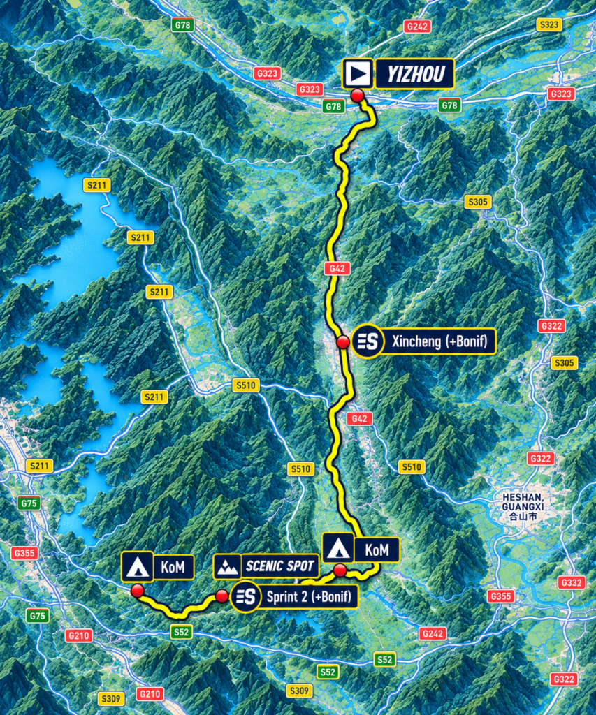
The Tour of Guangxi reaches its final day in Yizhou, where the previous stage ended among the river valleys and cultural traditions associated with Liu Sanjie. Over the following 170 kilometres, the race turns south through the interior of Guangxi towards Nongla, crossing the country around Xincheng before entering the limestone mountains of Mashan County. For much of the day the road follows inhabited valleys and agricultural landscapes where communities have adapted to the limitations of the surrounding hills. Only in the final kilometres does the character of the race change dramatically, as the road rises towards Nongla Scenic Spot and a finish more than 600 metres above sea level.
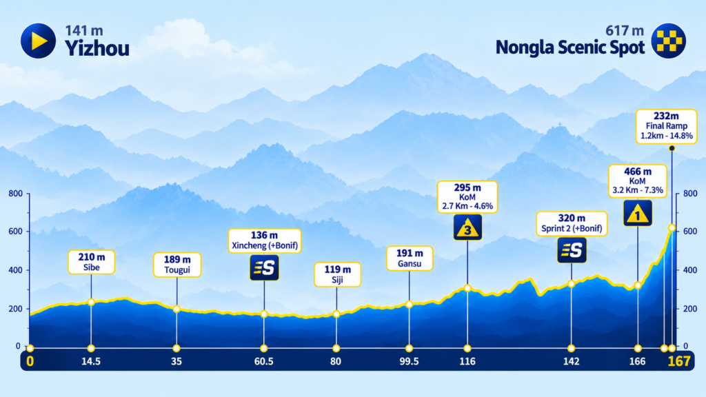
The profile is unusual for a mountaintop finale. During the opening hundred kilometres, the race rarely climbs far above 250 metres, and even the first classified ascent, reached after 116 kilometres, rises only to 295 metres. A succession of rolling hills follows, but the decisive obstacle remains concentrated at the very end: a Category 1 climb of 3.2 kilometres averaging 7.3 percent, with the particularly severe final ramp of 1.2 kilometres at 14.8 percent shown on the race profile. After five stages in which the mountains repeatedly shaped the entire journey, the final stage reserves its most demanding terrain for the approach to the finish.
The cultural landscape offers an equally revealing progression. Xincheng preserves one of southern China’s important architectural reminders of the tusi system, through which imperial governments recognised hereditary local rulers and incorporated mountain communities into wider structures of administration. Farther south, Nongla tells a different story about the relationship between communities and the land on which they depended, one involving environmental degradation, collective protection and the recovery of vegetation across limestone hills. Between these places lies a countryside where the availability of productive land, access to water and the difficulty of movement have influenced settlement and economic life for centuries.
The final stage therefore follows more than a route between two historical subjects. It moves through a landscape in which people have repeatedly confronted the same underlying problem: how to organise life, resources and authority within an environment that offers fertile valleys but imposes severe limits beyond them. The answers have changed across the centuries, from hereditary institutions of local government to modern programmes of ecological restoration, while the limestone mountains have remained a persistent influence on the possibilities available to the communities living among them.
–170 km | Yizhou · Leaving the Longjiang
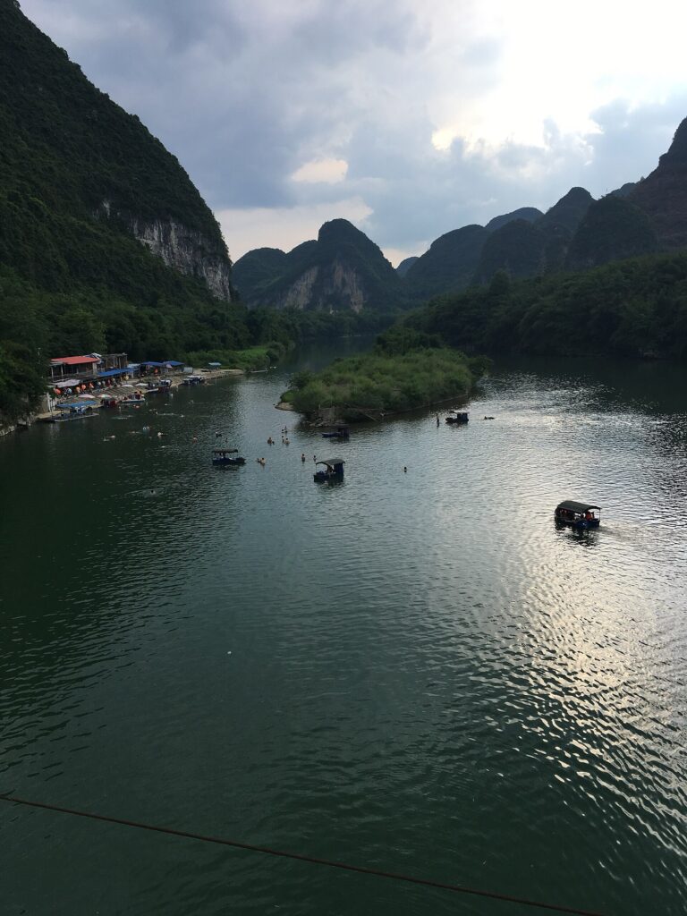
The peloton leaves Yizhou at approximately 141 metres above sea level, departing the Longjiang basin and the country whose oral traditions provided the cultural centrepiece of Stage 5. The river belongs to the wider Pearl River system that has connected much of the Tour’s geographical journey, but the road now turns away from its immediate valley towards the south, following a succession of lower corridors between limestone hills.
Yizhou’s position within this landscape helps explain its long-standing importance as a regional centre. The surrounding valleys offered cultivable land and routes through a mountainous interior, while the Longjiang connected settlements within a drainage network extending across northern Guangxi. Roads have since strengthened those connections, but their broad geographical logic remains visible: movement concentrates wherever the terrain provides enough continuous low ground to make travel practical.
The opening kilometres carry the riders through countryside in which agriculture occupies much of the flatter land and limestone hills rise beyond cultivated fields. The race passes Sibe after approximately fourteen kilometres, with the road around 210 metres above sea level, before continuing towards Tougui at kilometre 35. These settlements are not major historical destinations in their own right, but they belong to the inhabited geography that makes this stage different from the remote mountain crossings of the previous two days.
The relatively gentle opening introduces an important contrast. Around Fengshan and Tian’e, roads repeatedly climbed away from one valley into another, exposing the difficulty of movement through the mountain interior. Here the route can remain comparatively low for long distances, following the spaces in which villages, fields and roads have developed together. The same terrain that restricts cultivation on the steep slopes concentrates settlement in the valleys below, creating a pattern that becomes increasingly important as the race approaches Xincheng.
–135 km | Tougui · The Valleys of Xincheng
By Tougui, approximately 35 kilometres into the stage, the road remains below 200 metres. The peloton has travelled south through a succession of agricultural valleys, passing limestone hills whose steep slopes limit cultivation but whose intervening low ground supports the settlements scattered across the countryside.

The surrounding country belongs to the wider landscape of Xincheng County, where the relationship between geography and human settlement has a particularly long political history. Like much of inland Guangxi, Xincheng developed within a region where mountain barriers complicated movement and encouraged strong local networks of authority, while valleys and transport corridors connected communities to larger centres of power.
For centuries, governing such territory presented Chinese imperial administrations with a problem. Direct control from distant provincial centres could be difficult in regions where travel was slow, populations were culturally diverse and local authority often depended upon established relationships between families, villages and hereditary leaders. Rather than replacing every existing structure, successive dynasties frequently incorporated local rulers into the imperial administrative system.
That arrangement became known as the tusi system, and Xincheng preserves one of its most significant surviving architectural legacies.
The connection between the landscape and the institution is important. The mountains did not simply create picturesque isolation; they influenced how authority could be exercised, how obligations were collected and how communities interacted with governments whose political centres lay far beyond the immediate valleys. Agricultural land, local resources and the routes connecting settlements all formed part of the practical world in which local rulers exercised their power.
As the peloton approaches Xincheng, the history of those arrangements provides a more revealing subject than another description of limestone scenery. The landscape has remained recognisable, but the institutions through which people organised life within it have changed considerably.
–109.5 km | Xincheng · The Legacy of the Mo Tusi
The first intermediate sprint comes at kilometre 60.5 in Xincheng, at approximately 136 metres above sea level. The county seat occupies the lower landscape between the surrounding hills, but its historical importance extends far beyond its modest size.
Xincheng is particularly associated with the Mo Tusi Government Office, a substantial surviving complex connected with the hereditary Mo family, whose members exercised local authority under the tusi system. The institution developed through the relationship between imperial administration and recognised regional elites, allowing hereditary officeholders to govern local populations while formally operating within the authority of the Chinese state.
The system was neither complete independence nor ordinary provincial government. Tusi rulers could retain hereditary privileges and exercise considerable local influence, but their legitimacy depended upon recognition by the imperial court. They were expected to fulfil administrative and political obligations, while the extent of their practical autonomy varied considerably between regions and historical periods.
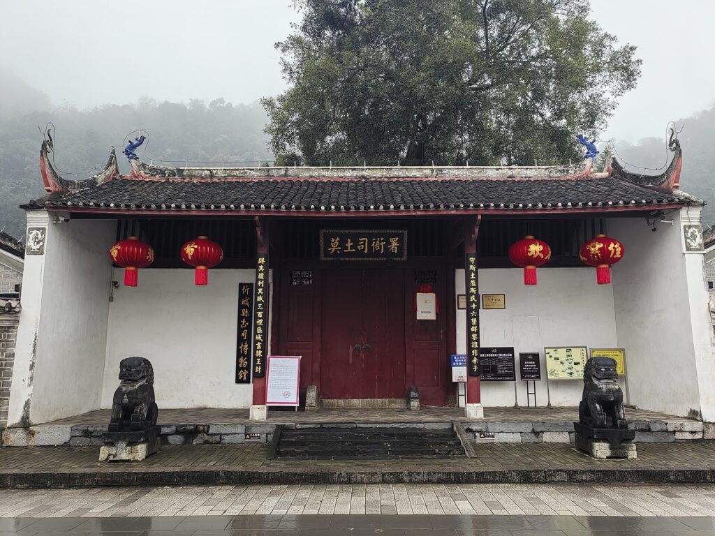
In Xincheng, the Mo family became closely associated with this form of government, and the surviving administrative compound offers a rare architectural expression of the institution. Its courtyards, halls and formal arrangement reflect the language of Chinese official architecture, while the hereditary authority exercised within them belonged to a political structure adapted to the circumstances of the southwestern frontier.
The buildings therefore preserve more than the memory of a local family. They reveal how imperial power could be translated into a region whose geography, communities and established political relationships made uniform administration difficult. Authority was exercised through recognised local intermediaries, creating institutions that combined imperial forms with regional continuity.
The tusi system gradually lost much of its importance as imperial governments expanded direct administration into formerly hereditary territories, particularly through reforms associated with the Ming and Qing periods. The process was uneven, and some hereditary offices survived far longer than others, but the broader direction was towards replacing local hereditary rulers with officials appointed through the regular administrative system.
Xincheng’s surviving complex provides a material reminder of that transition. Unlike the oral traditions associated with Liu Sanjie in Yizhou, this history remains visible in buildings designed to express authority through architecture, ceremony and controlled access. The contrast between the two neighbouring cultural landscapes is revealing: one preserves the memory of popular voices through songs and stories, while the other preserves institutions through which local political power was exercised.
The relationship between government and geography extended well beyond the administrative compound. Local authority operated within a countryside where productive land was unevenly distributed, transport depended upon mountain corridors and communities relied upon the resources available within their valleys. The buildings of Xincheng represent the institutional side of that relationship, while the agricultural landscape surrounding them reveals the material conditions within which it developed.
The race continues south, leaving the county centre behind as the road enters another stretch of inhabited countryside.
–90 km | Siji · Agriculture Between the Hills
At Siji, approximately eighty kilometres into the stage, the road has descended to around 119 metres. The surrounding terrain remains comparatively gentle, with the route following lower valleys rather than attempting to cross the more substantial ridges visible in the distance.
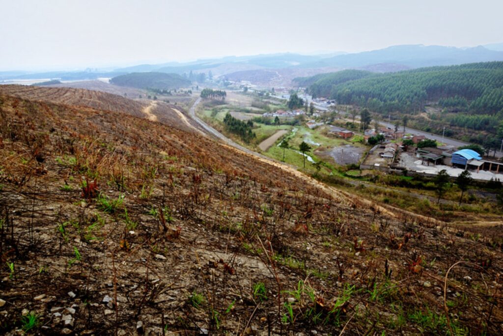
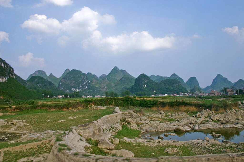
The rural landscape around Siji where cultivated lowlands are broken by the limestone hills characteristic of central Guangxi. (Photo: jiang-wen-jie / CC BY-SA 3.0 / Source: Wikimedia Commons, File: 合山市东矿 – panoramio.jpg)
The landscape here is best understood through the relationship between cultivated ground and the limestone hills that interrupt it. Agricultural settlements occupy the more usable land, while roads follow corridors connecting villages across the county. This pattern has persisted despite major changes in transport and farming because the underlying distribution of flat land remains determined by geography.
Rice cultivation is particularly suited to valley floors where water can be managed, while other crops occupy land according to soil depth, drainage and local conditions. On the surrounding slopes, however, the possibilities are considerably more restricted. Limestone terrain often contains thin, discontinuous soils, and the difference between a productive field and an exposed rocky hillside can be remarkably abrupt.
These conditions shaped everyday life long before the modern road network was established. Agricultural production depended upon access to suitable land, while the movement of produce and other goods relied upon routes connecting settlements through the mountains. Local government, whether hereditary or directly administered, operated within that same geography, where the distribution of land and resources affected both the livelihoods of communities and the practical exercise of authority.
As the race continues south, the landscape gradually becomes less accommodating. The valleys narrow, the hills gather more closely around the road and the availability of continuous agricultural ground begins to diminish. Beyond Gansu, reached at approximately kilometre 99.5, the route starts rising towards the first classified ascent, leaving behind the long, comparatively gentle passage through the countryside south of Yizhou.
–54 km | Towards the Southern Karst Hills
The first classified climb arrives at kilometre 116, a Category 3 ascent of 2.7 kilometres averaging 4.6 percent and reaching approximately 295 metres. Compared with the major climbs encountered earlier in the Tour, it is modest, but its appearance marks the end of the long passage through the lower agricultural valleys.

The surrounding landscape becomes more fragmented as the road approaches the broader mountain country of Mashan. Limestone hills rise more closely together, and the route begins negotiating shorter ascents and descents through terrain where cultivable ground is less continuous. The mountains are not especially high by the standards of the Tour’s earlier stages, but their steep slopes and irregular arrangement can make the available land considerably more difficult to use.
This distinction between elevation and agricultural potential is important. A landscape does not need to contain towering mountains to impose severe limits on cultivation. In limestone country, the distribution of soil can matter as much as altitude, while the ability of water to disappear through fractures and underground channels can make access to reliable surface water uneven. Some valleys provide productive agricultural land, while nearby slopes offer little opportunity for cultivation without disturbing fragile soils.
The route now enters a landscape where the consequences of land use become increasingly visible. As the peloton continues towards Mashan, the story moves from the organisation of agricultural communities to the environmental pressures that can emerge when those communities depend upon limited mountain resources.
The connection will become particularly clear at Nongla, where the condition of the surrounding hills has been shaped not only by natural processes but also by decades of decisions about how the land should be managed.
–28 km | The Approach to Mashan · A Fragile Landscape
The second intermediate sprint arrives at approximately kilometre 142, with the road around 320 metres above sea level. The peloton is now approaching the mountain country associated with Mashan County, where the final climb to Nongla will bring the six-day race to its conclusion.
Mashan belongs administratively to Nanning, the capital of Guangxi, but its northern landscapes retain much of the rugged character encountered throughout the Tour. Limestone hills dominate large areas, and the availability of soil and water has long influenced where communities could cultivate land. The hills around Nongla are especially revealing because their modern appearance cannot be explained through geology alone.
One of the characteristic environmental problems of southwestern China’s karst regions is rocky desertification, a process in which vegetation degradation and soil erosion expose increasingly extensive areas of underlying limestone. The term describes the deterioration of land rather than the formation of a conventional climatic desert. Where steep slopes possess only thin layers of soil, clearing vegetation for cultivation, collecting wood and other forms of sustained pressure can make that soil increasingly vulnerable to erosion.
Rainfall plays a central role in this process. Vegetation intercepts rain, while roots help retain soil and plant cover reduces the force of water striking exposed slopes. When that protection disappears, heavy rainfall can accelerate erosion, carrying away the thin soils on which mountain agriculture depends. In karst terrain, where water can also drain rapidly through fractures and underground channels, the loss of soil may be particularly difficult to reverse.
The relationship connects Nongla with the wider geographical story of the Tour. Around Fengshan, water disappeared beneath the mountains and followed hidden routes through limestone. At Tian’e, the Hongshui demonstrated how rivers could be transformed through engineering. In Mashan, the consequences of water moving across exposed slopes reveal another dimension of the same natural system, one in which the survival of vegetation influences whether rainfall sustains a landscape or contributes to its degradation.
Around Nongla, these pressures became serious enough to threaten the resources upon which local families depended. The response developed through community efforts to protect the remaining forest, restore vegetation and change the ways the surrounding mountains were used.
The road towards the finish therefore approaches a landscape with a history that is not immediately apparent from its present appearance. The green slopes visible today are part of an environmental recovery that began long before Nongla became a scenic destination or a familiar name in professional cycling.
Nongla · The Mountains That Grew Green Again
Nongla lies in Guling Town, Mashan County, within a limestone landscape whose environmental history has made it one of Guangxi’s notable examples of ecological restoration. Its name is commonly explained locally as referring to a small area of relatively level ground high among the mountains, an appropriate description of a settlement surrounded by steep karst slopes and limited cultivable land.
The community’s environmental recovery began through local efforts to protect the remaining vegetation and reduce pressure on the surrounding hills. Accounts of Nongla’s restoration history describe measures introduced during the 1960s to restrict tree cutting and safeguard forest resources, including community rules established in July 1967. Those decisions formed part of a longer process through which residents sought to protect the land upon which their future depended.
The importance of those measures lies partly in their local origins. Environmental protection required residents to accept restrictions on activities that could provide immediate benefits, including the use of trees and other vegetation from the surrounding slopes. The longer-term advantages were less certain and depended upon sustained cooperation, making the recovery of the mountains a social achievement as well as an ecological one.
Over time, the protection of vegetation allowed forest cover to recover across parts of the surrounding landscape. As plant cover increased, it helped reduce erosion and improve the stability of vulnerable soils, creating conditions more favourable to the continued recovery of the ecosystem. The changes were gradual, and they did not remove the underlying limitations of the limestone terrain, but they demonstrated that environmental degradation was not necessarily irreversible.
The recovery also created opportunities to reconsider the local economy. Rather than relying exclusively upon activities that placed pressure on vulnerable slopes, Nongla developed a model combining forest protection, suitable agricultural production and, increasingly, ecological tourism. The restored landscape became an asset in its own right, attracting attention from visitors interested in the region’s limestone scenery and the history of its environmental rehabilitation.
That development brought new opportunities and new responsibilities. Roads, visitor facilities and tourism infrastructure improved access to a place once constrained by its mountain location, while the continuing appeal of Nongla depended upon maintaining the environmental conditions that restoration had helped create. The community’s relationship with the mountains consequently changed from one dominated by the scarcity of productive land towards an economy in which the protection of the landscape could itself support livelihoods.
Nongla’s experience is particularly significant within the wider history of Guangxi because it illustrates a different response to the geographical constraints encountered throughout the Tour. Around Xincheng, those constraints formed part of the historical setting in which hereditary local government developed and agricultural communities organised their lives. In Nongla, the scarcity and vulnerability of mountain resources eventually encouraged a collective effort to protect and restore the surrounding environment.
The two histories should not be treated as successive stages of a single political process. They belong to different periods and circumstances, and there is no need to suggest that the institutions of Xincheng directly anticipated the environmental initiatives of Nongla. Their connection is geographical and human: both concern communities attempting to organise life within a landscape that places real limits on land use, movement and access to resources.
The green slopes surrounding Nongla are therefore not simply an attractive natural backdrop. They are part of a landscape whose present condition reflects decades of human decisions, beginning with local efforts to protect vegetation when the mountains offered far fewer economic opportunities than they do today.
That history gives Nongla an unusually appropriate place at the end of the Tour of Guangxi. After six days travelling through environments shaped by rivers, geology, agriculture, settlement and engineering, the race finishes in a landscape where the recovery of the natural environment has itself become an important part of local history.
–3.2 km | Nongla · The Final Ascent
The Category 1 climb to Nongla begins with only 3.2 kilometres remaining. Its average gradient of 7.3 percent makes it a demanding finish, but the overall figure conceals a much more severe final section. According to the supplied profile, the last 1.2 kilometres average 14.8 percent, turning the approach to the scenic area into a sustained test of climbing strength after almost an entire day spent on comparatively gentle roads.
The ascent has become one of the defining features of the Tour of Guangxi. Since the race joined the UCI WorldTour calendar in 2017, Nongla has repeatedly provided the terrain on which the strongest general-classification riders could separate themselves from the rest of the field. Its difficulty lies in the concentration of the steepest gradients close to the finish, where the ability to accelerate, sustain effort and manage rapidly increasing resistance becomes more important than the long-distance climbing rhythm required on Alpine or Pyrenean passes.
The history of the race reflects that character. In 2023, Milan Vader used the Nongla finish to establish the advantage that carried him to overall victory. Lennert Van Eetvelt followed in 2024, while Paul Double won on the climb in 2025 and subsequently secured the general classification. Different riders and circumstances produced different races, but the underlying geographical advantage remained consistent: Nongla offered enough difficulty to create meaningful time gaps within a relatively short distance.
The 2026 edition changes the significance of the ascent by placing it on the final day. In previous years, the climb could establish the general-classification order before subsequent stages offered opportunities to defend or, occasionally, challenge that advantage. This time the road ends at Nongla, and there is no following stage in which to recover lost time.
The ascent also reveals something about the transformation of the surrounding landscape. The road now carries an international cycling race towards a scenic destination whose development was made possible partly by the recovery of the mountains themselves. The infrastructure, tourism and public attention associated with Nongla belong to a much more recent chapter than the community’s original environmental efforts, but they are connected through the changing value attached to the landscape.
As the riders enter the final steep ramps, the restored limestone hills rise around the road. The gradients are severe enough to make the last kilometre feel considerably longer than its measured distance, while the finish approaches through mountain scenery that has become inseparable from the identity of the race.
The climb therefore provides both the sporting conclusion and the final geographical image of the Tour: a road rising through the green slopes of a landscape whose recovery began long before professional cycling arrived.
FINISH · Nongla Scenic Spot
The Tour of Guangxi ends at Nongla Scenic Spot, approximately 617 metres above sea level. The final climb has carried the riders from the lower valleys of Mashan into the limestone hills, completing a stage that began beside the Longjiang in Yizhou and travelled south through the historical country of Xincheng before reaching the restored mountain landscape of Nongla.
The day’s journey has followed a changing relationship between communities and the land available to them. Around Xincheng, the historical structures of local government developed within a region where mountain barriers, agricultural resources and established community relationships influenced the exercise of authority. Farther south, the increasingly fragmented limestone landscape revealed the environmental limits of cultivation, culminating in Nongla’s efforts to protect vegetation and recover land damaged by erosion.
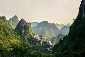
These histories belong to different centuries and should not be forced into a single explanation. What connects them is the persistent influence of geography upon human decisions, and the equally important capacity of communities to alter the ways they live within that geography. The mountains constrained settlement and agriculture, but they did not determine one unchanging response. Institutions evolved, land-use practices changed and communities developed new relationships with the resources surrounding them.
At Nongla, that process remains visible in the landscape itself. The restored hills represent decades of protection and recovery, beginning with local decisions made when the surrounding mountains offered limited economic opportunities. The later development of tourism and the arrival of the WorldTour have given the area a wider reputation, but the environmental work that helped make those developments possible belongs to an earlier and less visible history.
There is also a final connection to the water that has accompanied the Tour throughout Guangxi. The same rainfall that feeds rivers, disappears into limestone and moves through the immense Pearl River drainage system can also carry soil away from exposed mountain slopes. At Nongla, the recovery of vegetation changed how the landscape responded to that water, protecting the fragile ground on which the community depended. The relationship between people and their environment, explored through rivers, caves, reservoirs and inhabited valleys during the previous stages, reaches its conclusion here through the restoration of a mountain ecosystem.
By the time the final riders reach the summit, the sporting contest will have been settled and the Tour’s journey across Guangxi will be complete. Beyond the finish barriers, however, the landscape continues to tell a story that cannot be reduced to a race result. The green mountains of Nongla are not merely the scenery through which the peloton has climbed, but evidence of how profoundly a place can change when the people living within it decide that its future must be different from its past.



